QARĀRA (HIPPŌNŌN)
Place names
| Greek | Ἱππώνων |
| Latin | Hipponos | Hipponon |
| Arabic | جبل كرارة | كرارة |
| English | (Gebel) Qarara | (Gebel) Karara |
Site map
Site information
| DEChriM ID | 35 |
| Trismegistos GeoID | 2634 |
| Pleiades ID | 736924 | PAThs ID | 431 |
| Ancient name | Hippōnōn |
| Modern name | Qarāra |
| Latitude | 28.648235 |
| Longitude | 30.874145 |
| Date from | - |
| Date to | - |
| Typology | Uncertain |
| Dating criteria | - |
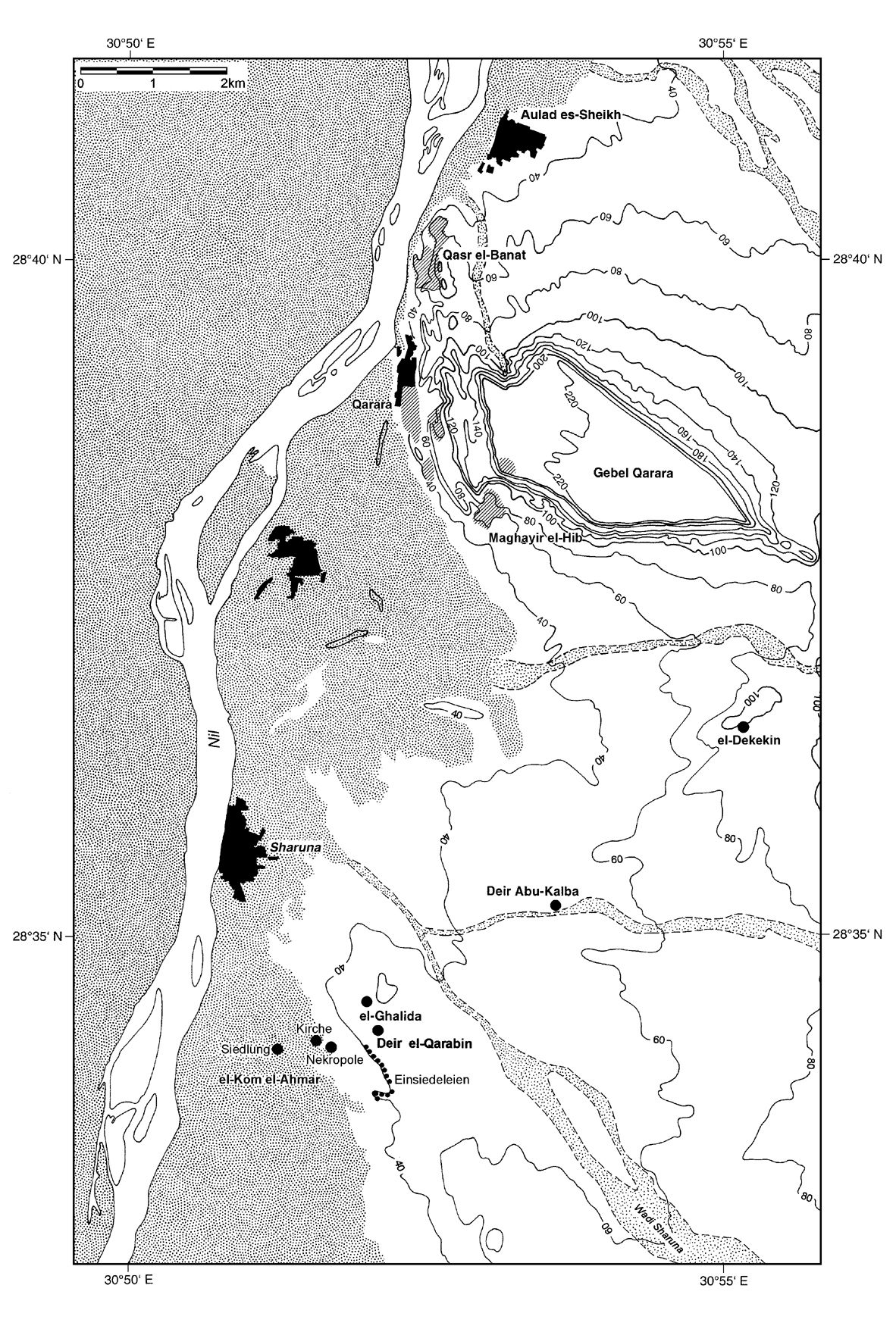
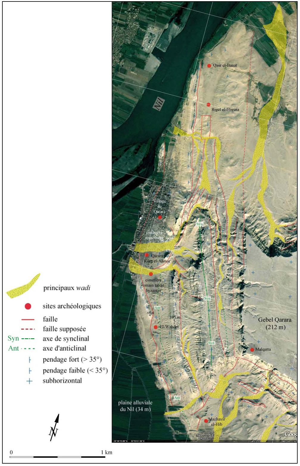
| Description | Qarāra is located 10km north of the site of Šārūna/Kūm al-Aḥmar Sawāris. The site includes a modern village which lies between the foot of the Ğabal Qarāra and the Nile. To the south of the settlement is a Muslim cemetery, and to the south of that is the modern Coptic cemetery, in use from the 19th century. The modern settlement and both of these cemeteries are built on top of the ancient Coptic cemetery, which appears to extend some 450 meters from north to south and 350 meters east to west (Huber 2008: 55). The 1926 publication describes two cemeteries, one in the north, and one in the south, which are now understood to have been the extremities of this single cemetery. While there remains a large area to the south which is not obstructed by modern structures, looters have destroyed the integrity of much of the ancient remains. While the information published about the early excavations is limited, it appears that the work in the first year (1913) was concentrated on three places: (1) immediately north of the Muslim cemetery, east of the settlement ruins, (2) in the ǧabal foothills, and (3) southeast of the modern Coptic cemetery (Huber 2008: 59). These areas remained the focus in the second year (1914) and were partially expanded; the area to the north is now covered by modern graves (Huber 2008: 59). The cemetery appears to have had at least two occupancy periods, but they do not differ by burial type or the material found (Huber 2008: 70). The dead are all extended supine, with their arms parallel to their body, oriented east-west with their heads to the west (Ranke 1926: 2). Several shrouds are often present, made of undyed and undecorated linen, all of which was finally covered with a palm mat (Huber 2008: 64). Many of these textiles were piled up over the face, creating somewhat of a roof-like structure, which were then adorned with colourful ribbons in criss-cross patterns (Ranke 1926: 3; Huber 2008: 57). Unfortunately, only the textiles that were decorated were kept by the early excavators. Many of the interments were accompanied by grave goods, including various items of jewelry and amulets, fragments of wooden combs, as well as a man, presumed to have been a scribe, who was buried with an inkpot and a leather pen case containing reed pens, others were buried with instruments (Grenfell, Hunt 1902-3: 3; Huber, 2008: 66). A number of inscribed wooden tablets were also uncovered by Grenfell and Hunt, one of which contained the beginning of St. Matthew’s gospel in Sahidic (Grenfell, Hunt 1902-3: 4). An additional unique find was the “Peacock Coffin”, the only painted Coptic coffin uncovered to date (Ranke 1926: 3-4; Huber 2008: 58). This coffin, and others which have since been found, have a unique triangular feature over the head (Huber 2013: 78). Coffins with this pyramidal feature have only been found here, at Qaṣr al-Banāt, Tebtunis and Saqqāra (Huber 2013: 81) The ancient remains of the site are not restricted to graves, with traces of buildings also identified in the northwest corner of the excavation area. Because the structure would have been situated in the middle of the cemetery, Ranke suggested that perhaps it was a monastery, and this classification has since gone unquestioned in the relevant literature, although there is limited evidence to support such a claim (Ranke 1926: 16; Huber 2008: 58). The only potential indications of the presence of a sacred building in this area is a tower standing 150 meters south of the structure identified by Ranke, with 1.10m thick walls (Huber 2008: 61; Huber 2012: 81). The structure does not appear to have been accessible via the ground floor and must have instead been accessed with the help of an external staircase, like that seen at Dayr al-Qarābīn in Šārūna/Kūm al-Aḥmar Sawāris, or a ladder (Huber 2012: 82). This is in addition to a grave stela uncovered with the word ‘Apa’, an honorary title attributed to a spiritual individual, namely monks (Huber 2012: 81). East of the ancient cemetery, situated on a somewhat levelled-out area of the ǧabal, are three settlement points which have been identified thanks to ceramic, scattered mud-bricks, the foundations of walls, and clay floors (Ranke 1926: 7; Huber 2008: 60). To the north of this are evidence of settlement and graves on a small terrace of about 150x150m. To be located in such a place, accessed only by a narrow and steep path, raises a number of questions. Was it a small hermitage, or perhaps an observation post? The vantage point one has here perhaps argues in favour of the latter (Huber 2008: 60-61). Further south along the ǧabal, at Maġāʾwir al-Hīb, are numerous traces of settlement, including numerous caves (as the name suggests) considered to have been furnished dwellings (Huber 2008: 61). |
| Archaeological research | The site was first visited at the beginning of the 20th century by Grenfell and Hunt who were searching for papyri and mummy masks. They were disappointed with their discoveries, and only briefly recorded their work (Grenfell, Hunt 1902/3: 3-4). This was followed by two seasons of fieldwork by the University of Heidelberg which focused on the cemetery at Qarāra, and the Scheschonk temple near El-Hibe. Denoted the “Baden Excavations”, the work was carried out in 1913 and 1914, with similar aims and work ethics as Grenfell and Hunt. The work in 1913 was somewhat of a scouting mission (research excavation), lasting only 6 days, led by Hermann Ranke. The campaign proper was conducted the following year, under the direction of Hans Abel, lasting for four weeks. Much of the material from these campaigns is now in the Völkerkundmuseum in Freiburg and in the collection of the Egyptological Institute of the University of Heidelberg. While these campaigns uncovered hundreds of graves and artefacts, relevant publications are limited to a monograph authored by Ranke published in 1926. This work is a relatively basic presentation of material, with no information regarding stratigraphic context or find spots. Additional information can be gleaned from the unpublished handwritten fieldwork journals, and accompanying site photos. Claudia Nauerth revisited this material, as well as that from El-Hibe, publishing a catalogue in 1996. Unfortunately, it is not always clear which site the material originates from. The site appears to have been mostly forgotten about until the Egyptian Antiquities Department, now the Supreme Council of Antiquities, carried out work in 1981, 1983 and 1996/7. This work revealed parts of an anepigraphic temple (Ptolemaic), an animal cemetery (including burials of dogs, birds and cattle), and the Coptic and Roman graves which dominate the site. Between 2001 and 2003/4, a separate burial area, 300m south of the cemetery was identified, containing burials from the Ptolemaic to Roman era. Since 2008, the Egyptological Institute, Institute for the Cultures of the Ancient Orient, University of Tübingen, have carried out numerous surveys and archaeological excavations of the site. Surveys were carried out in 2003 and 2008 as far as Qaṣr al-Banāt in the north and Maġāʾwir al-Hīb in the south, with ceramic assemblages, both surface and sub-surface, dating from the fourth to the seventh or eighth centuries (Huber 2008: 60, 65). From March 10th to April 9th 2008, four soundings were carried out: three in the settlement area and one in the cemetery (Huber 2008: 61). |
Bibliography
• Grenfell, B. P. and A. S. Hunt. 1902-1903. “Graeco-Roman Branch. Excavations at Hîbeh, Cynopolis and Oxyrhynchos.” Archaeological Report (Egypt Exploration Fund) 1-9.
• Huber, B. 2008b. “Mittelägypten in Spätrömisch-Byzantinischer zeit: neue Forschungen in Qarara.” Bulletin de la Société d'archéologie copte 47: 53-71.
• Huber, B. 2013. “Ein Koptischer sarg zwischen Tradition und Innovation.” Bulletin de la Société d'archéologie copte 52: 77-83.
• Huber, B. 2018. “The Early Christian Cemeteries of Qarara and Sharuna, Middle Egypt.” In Death and Burial in the Near East from Roman to Islamic Times. Research in Syria, Lebanon, Jordan and Egypt, edited by C. Eger and M. Mackensen, 207- 226. Wiesbaden: Reichart Verlag.
• Huber, B. 2018. “Coptic Coffins from Qarara. The Pfauensarg (peacock coffin) in Context.” In Ancient Egyptian Coffins. Craft Traditions and Functionality, edited by J. H. Taylor and M. Vandenbeusch, 435-569. Leuven: Peeters.
• Metzger, H. and H. Harrauer. 1985. “Einige Giessener Papyri.” Zeitschrift für Papyrologie und Epigraphik 60: 246-248.
• Nauerth, C. 1996. Karara und El-Hibe. Die spätantiken („koptischen“) Funde aus den badischen Grabungen 1913-1914. Heidelberg: Heidelberger Orientverlag.
• Ranke, H. 1926. Koptische Friedhöfe bei Karara und der Amontempel Scheschonks I bei El-Hibe. Berlin-Leipzig: Walter de Gruyter.
Authors
Suggested citation
 Json data