DAYR MUṢṬAFĀ KĀŠIF
Place names
| Arabic | قصر عين مصطفى كاشف | دير مصطفى كاشف |
| French | Deir Mustafa Kashef | Deir Moustafa Kachef | Deir Mustapha Kâshef | Qasr Ayn Moustafa Kachef | Qasr Moustafa Kachif |
| English | Deir Mustafa Kashif | Ain Mustafa Kashif | Qasr Ayn Mustafa Kashif |
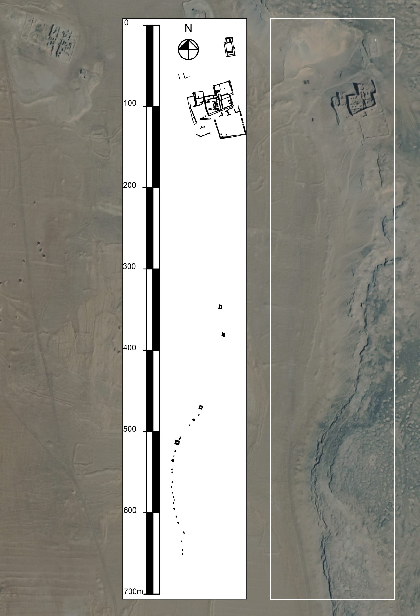
Site map
Site information
| DEChriM ID | 17 |
| Trismegistos GeoID | 59094 |
| Pleiades ID | 776168 | PAThs ID | 413 |
| Ancient name | - |
| Modern name | Dayr Muṣṭafā Kāšif |
| Latitude | 25.493538 |
| Longitude | 30.554104 |
| Date from | -200 |
| Date to | 660 |
| Typology | Monastic settlement |
| Dating criteria | 14C; ceramic ware found during the 2021 and 2022 excavation seasons; textual material. |
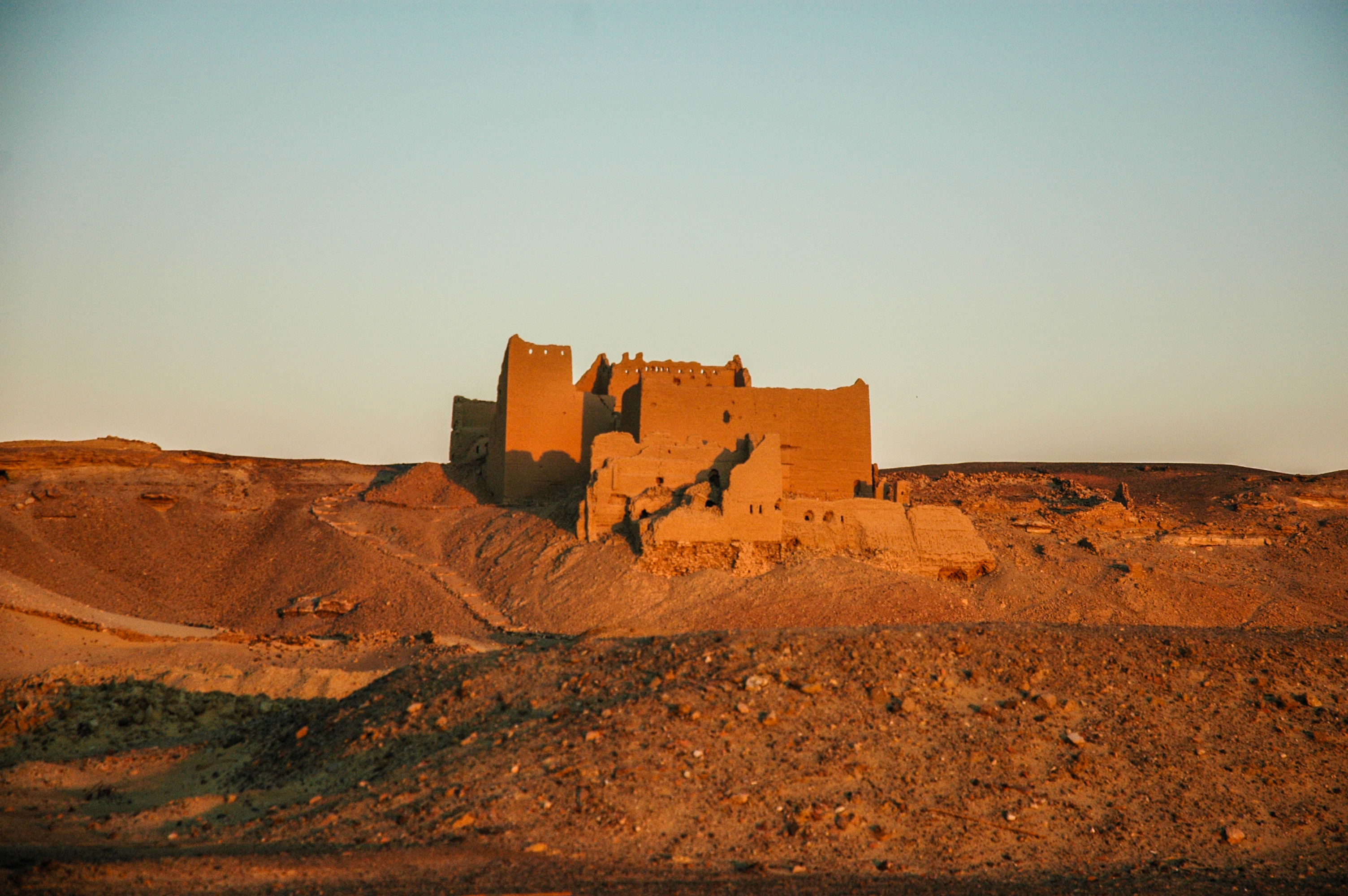
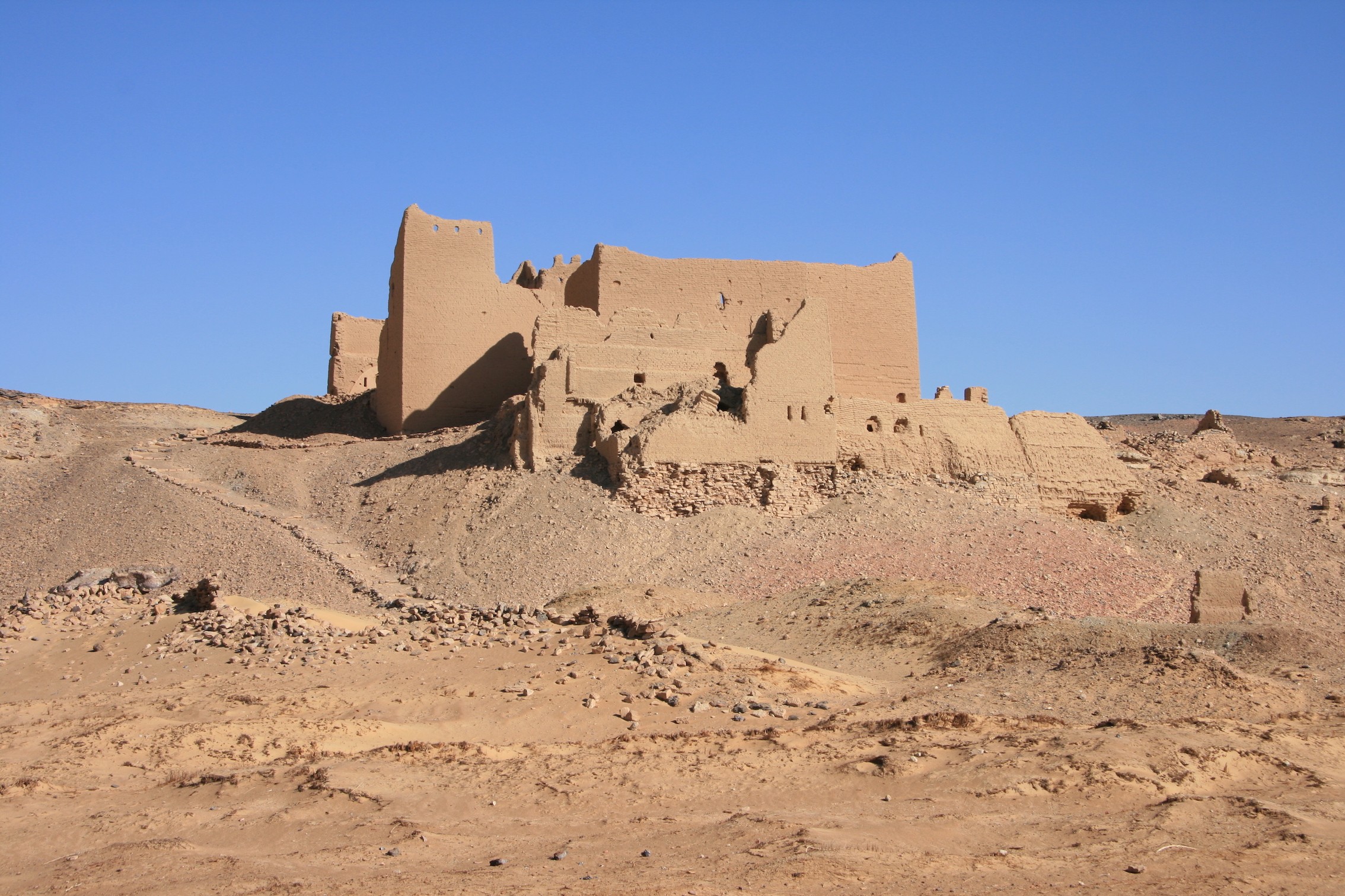
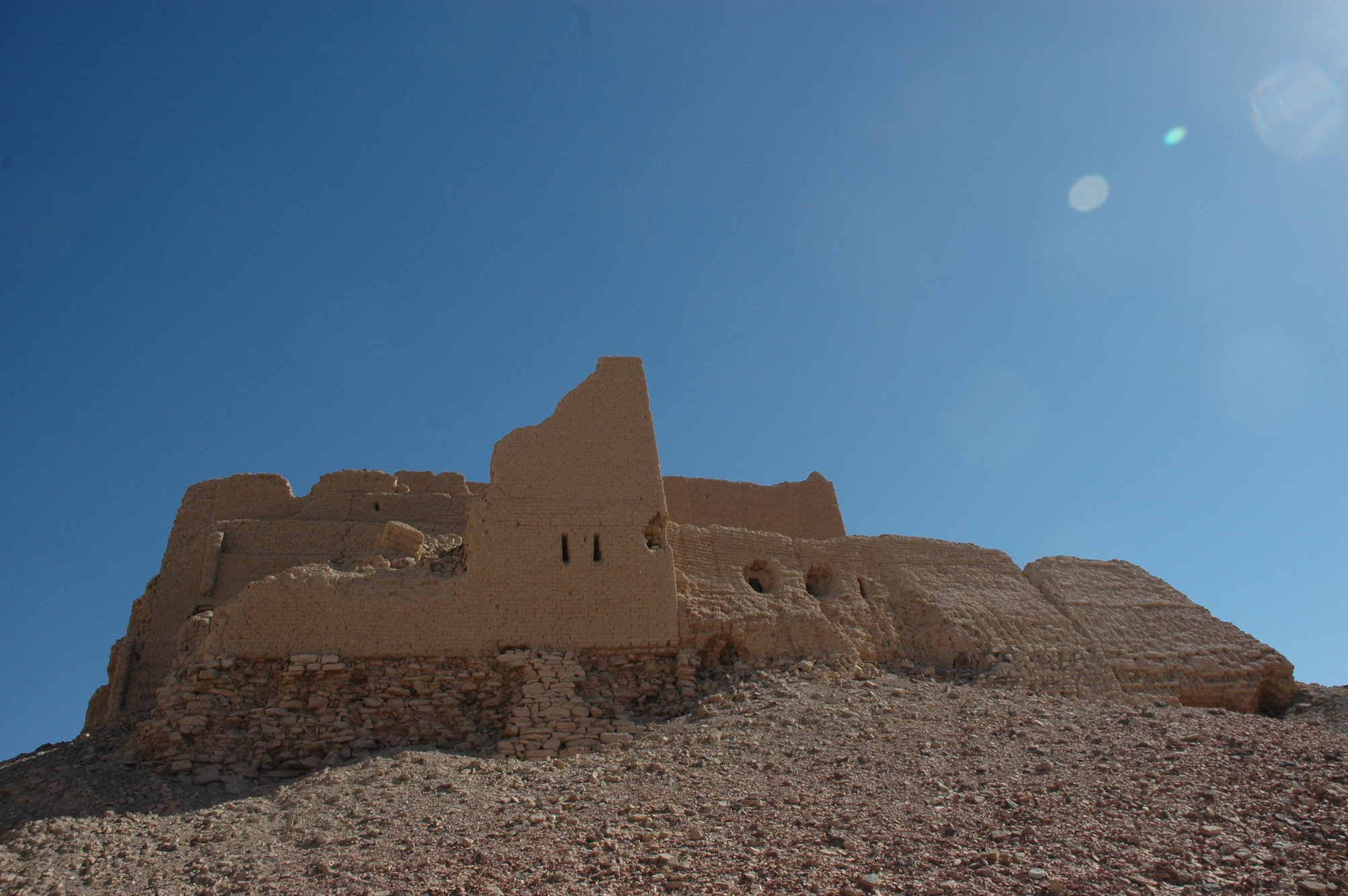
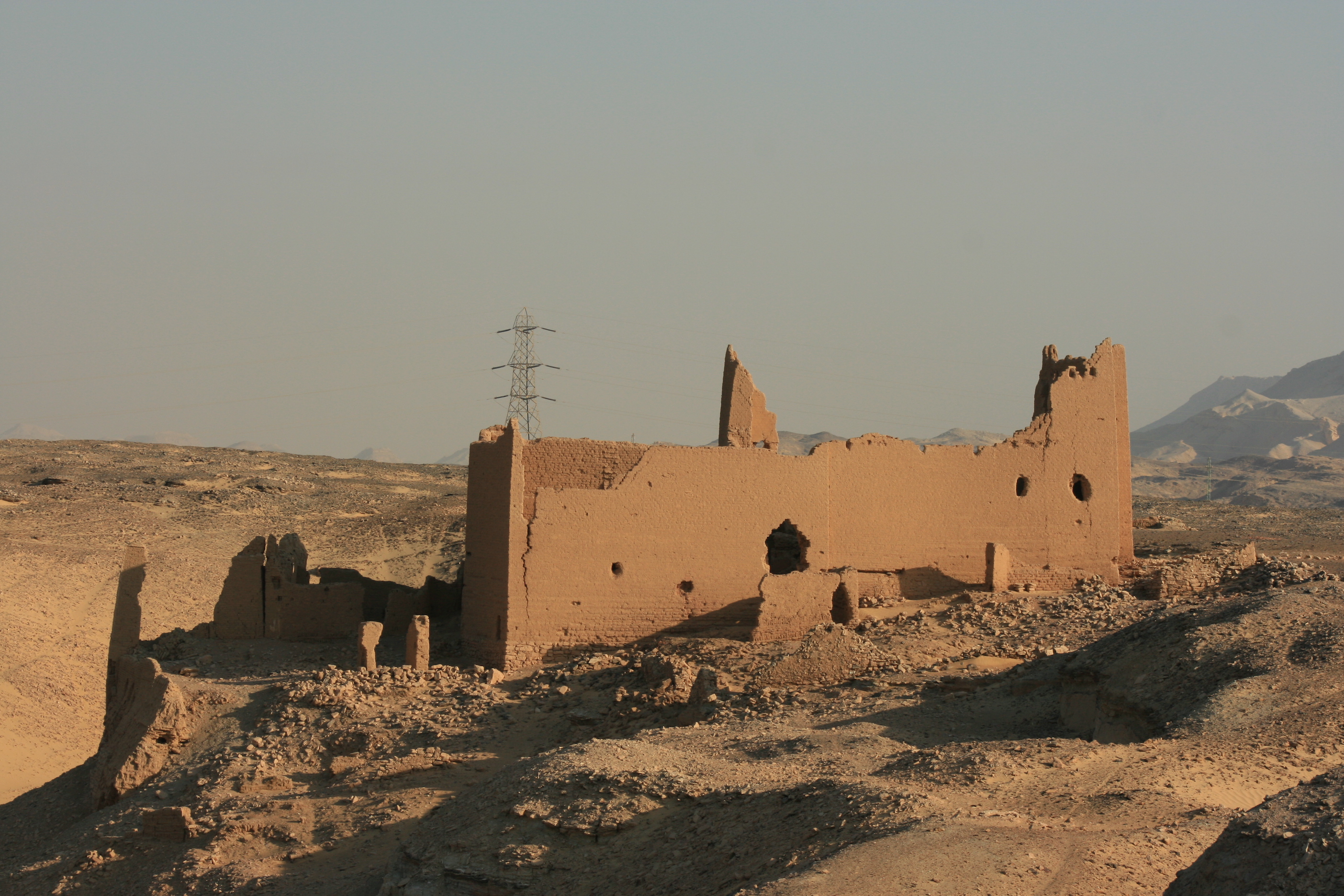
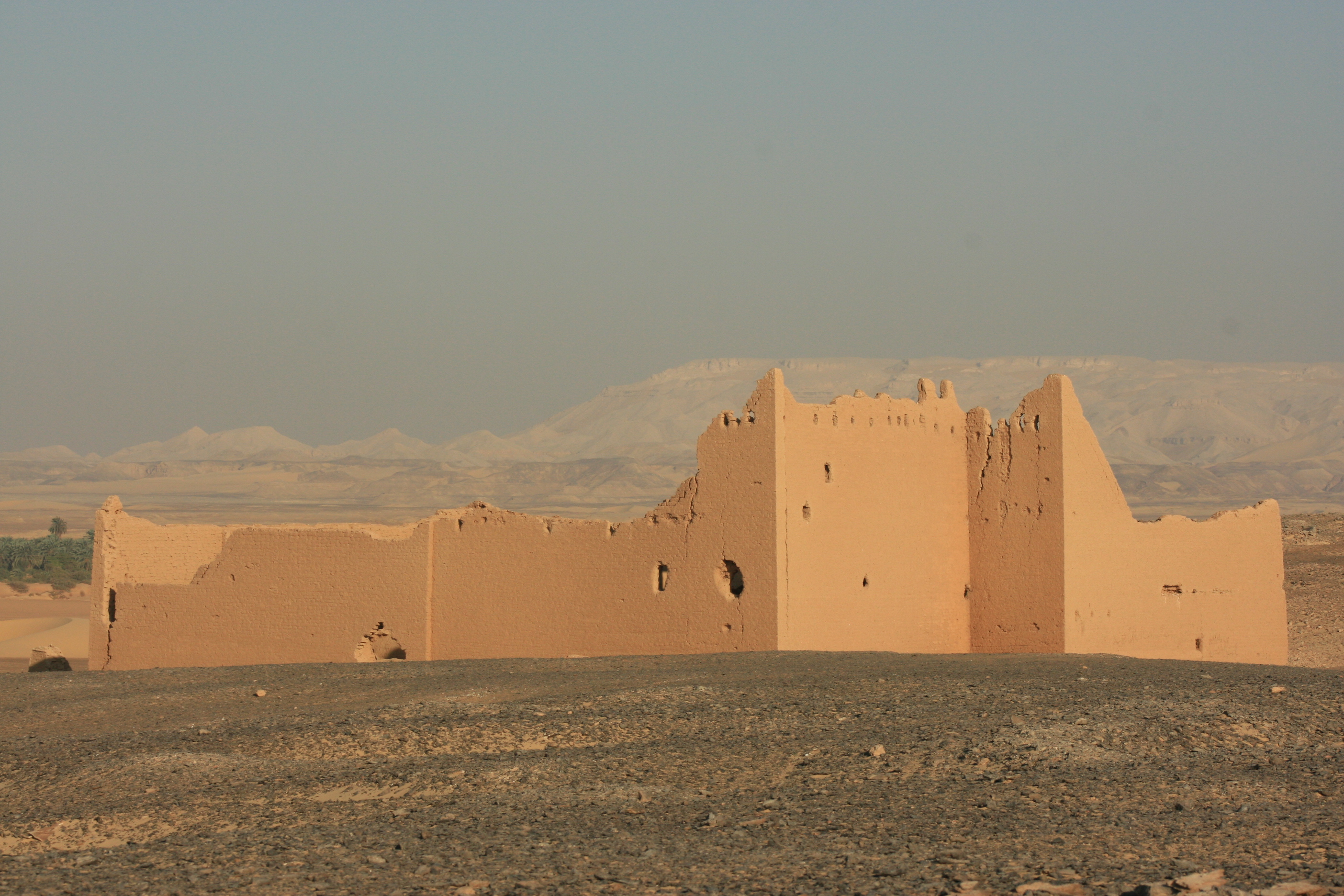
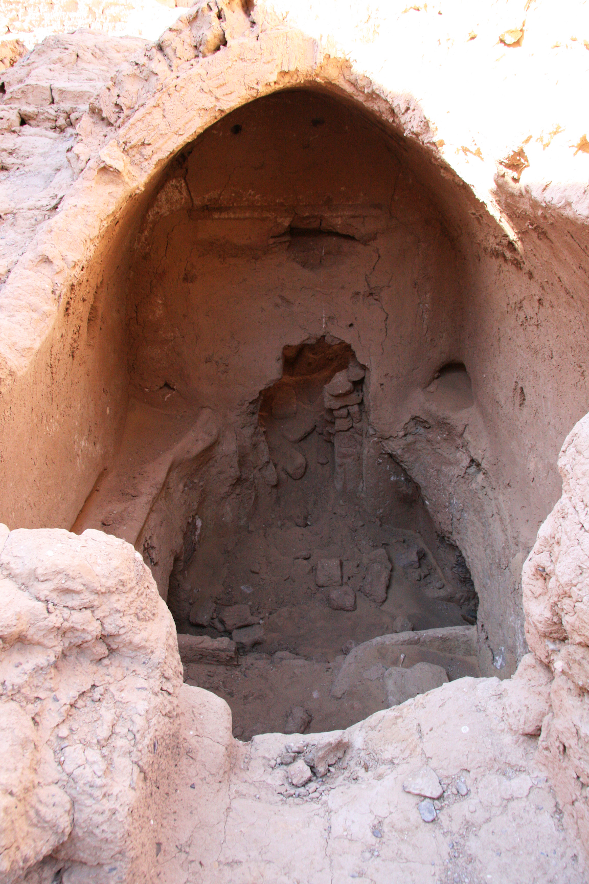
| Description | Dayr Muṣṭafā Kāšif (also known as Qaṣr ʿAyn Muṣṭafā Kāšif) occupies the south-west cliff of Ǧabal al-Ṭayr, overlooking the Darb al-Arbaʿīn and the valley floor to the west. The complex lies immediately north of the al-Baǧawāt necropolis and in visual and functional proximity to the monastic settlement of Dayr al-Baǧawāt (Ghica 2012: 199). In topographic terms, it is situated ca. 620 m north of the northernmost chapel at al-Baǧawāt, and only a short distance east of Dayr al-Baǧawāt itself. The monument is a multi-storey mudbrick structure measuring roughly 27.5 × 23.5 m, with enclosing walls reaching c. 9.8 m in preserved height; several annexed spaces extend to the north and west. From the exterior, the high perimeter walls can appear “fortified”—an impression already noted in early accounts (Lythgoe 1908: 86)—but the internal organisation is characteristic of a large, compartmentalised communal complex, including stacked residential units and circulation corridors. One of its most distinctive features is the second-storey church in the south-east corner, a rare (and presently unique) case in Egypt of a late antique church preserved on an upper level.
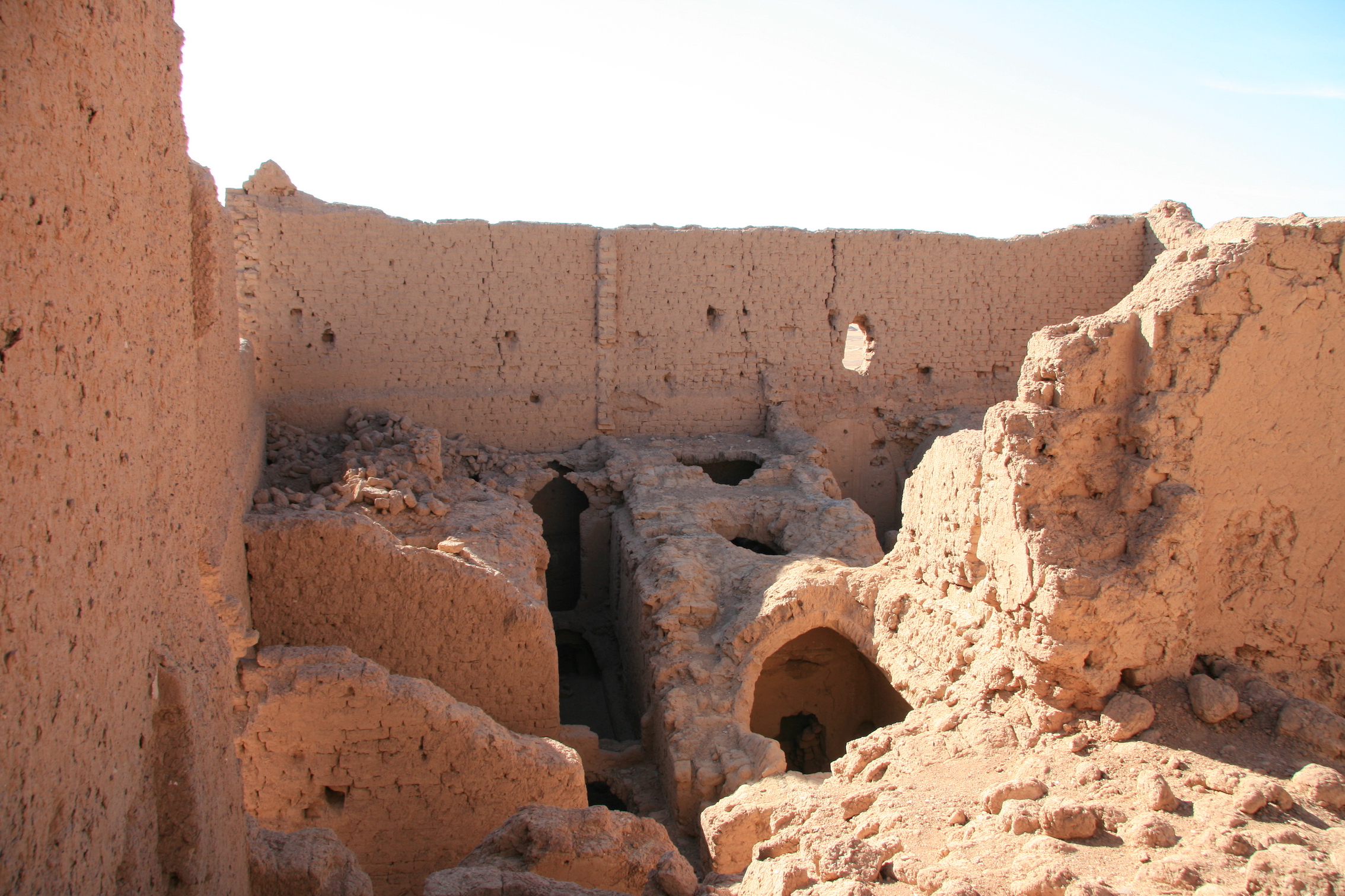
Architectural articulation and longer-term development Earlier interpretations proposed that the standing complex developed around an initial, relatively small structure thought to be a Ptolemaic temple (Ghica 2016: 202), followed by a substantially larger addition under the Principate—often described as having an administrative or military function—immediately to the east, possibly sharing a wall with the earlier building (Ghica 2012: 202; 2019: 132 & fig. 9). These hypotheses remain important for understanding the architectural palimpsest, especially because the “nucleus” identified by Müller-Wiener—an east-west succession of vaulted spaces including a room partly cut into the substratum—still appears to preserve an earlier core around which later construction accreted (Müller-Wiener 1963). Recent fieldwork continues to recognise this western vaulted unit as structurally central to the monument’s growth. At the same time, the most recent excavation evidence substantially refines the site’s functional and chronological reading. Rather than a late conversion of an earlier secular building into a monastic space, the main building’s principal occupation is now securely monastic already in the fourth century, and the core architectural programme—including liturgical space—belongs to an early stage in the life of the complex.
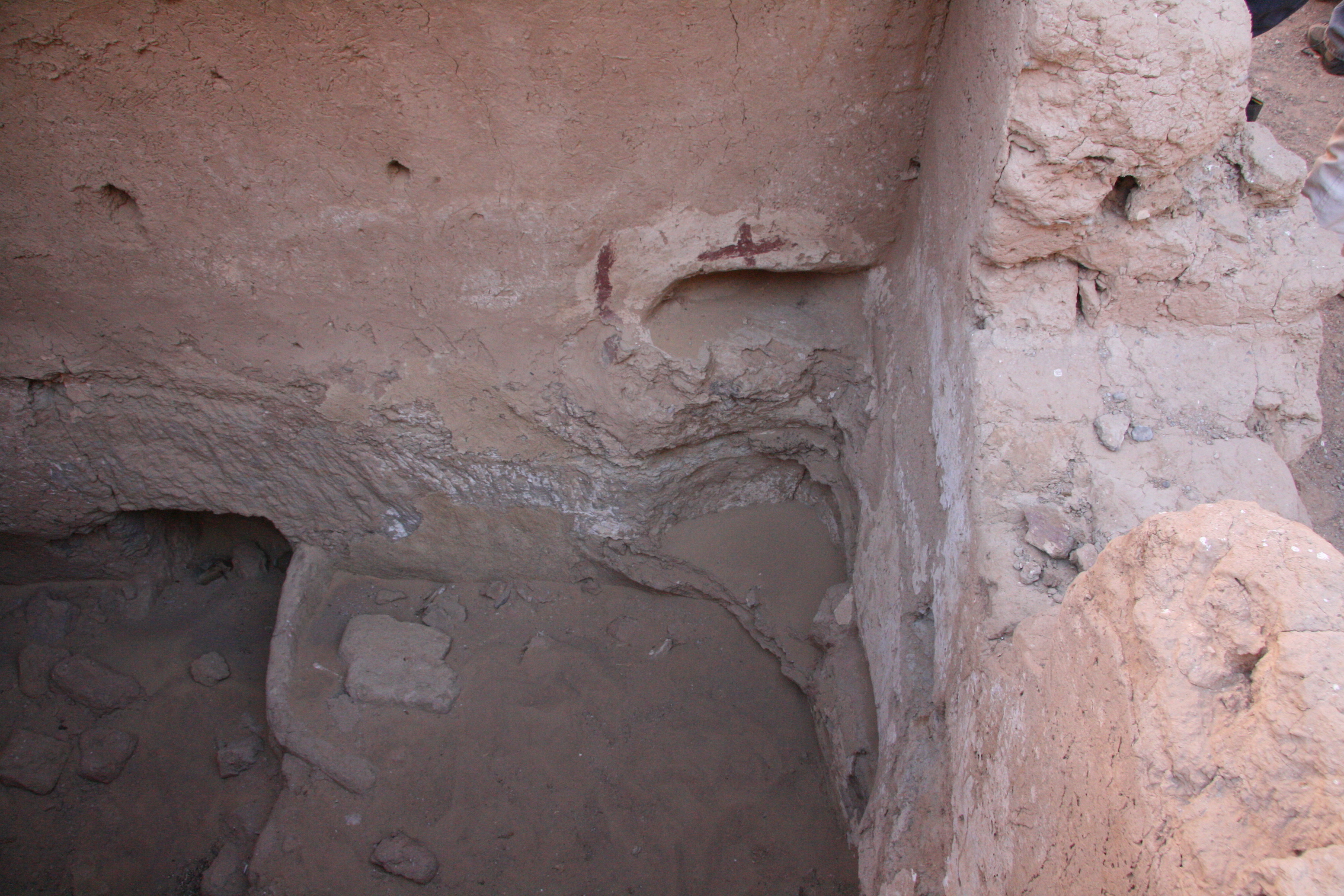
Monastic function and fourth-century phasing (new excavation evidence) Excavations in and beneath the church sector demonstrate that the church and its immediate substructures were integral to early use of the complex. The 2022 season, focused on the second-storey church and the corridor bordering it to the west, revealed a stratigraphy affected by collapse and substantial reworking, yet still sufficiently coherent to isolate early occupational horizons and reconstruct major events. The first attested occupation of the church (“church phase 1”) is associated with contexts and finds that include documentary material (ostraca and wooden tablets; Ghica et al. 2025), and it ended with a fire that caused the collapse of the church’s initial wooden floor. On the basis of the excavation sequence and associated chronological modelling, recent work places the construction of the main building (as presently understood in the excavated sector) in the range 360–373 CE and dates the fire/collapse event to 360–382 CE. This fire is not merely inferred from deposits: it is also consistent with visible burning traces on walls and with partially burnt archaeological material. Importantly, the post-fire history of the complex is now more nuanced than earlier summaries allowed. New excavations indicate an interval of pastoral reuse after the fire, implying at least a temporary interruption (or transformation) of monastic life. In room R21—interpreted in its primary phase as an oratory beneath the church—two later-built trough installations, raised thresholds, and a dung layer across the floor point to conversion into a stable. A comparable horizon appears in the large hall R25, where deposits of dung/straw and small fire/charcoal concentrations indicate animal husbandry in a later, temporary occupation following collapse but prior to further major structural failures. Subsequently, the church underwent a restoration episode (“church phase 2”), including a new floor and wall painting, dated (on present evidence) to 420–533 CE (2σ), indicating a return of the building to a clearly religious/monastic function after the post-fire pastoral episode.
Communal spaces and internal organisation (new evidence) Recent work also clarifies the internal zoning of the monastery. The large room R25—second in scale only to the church—was initially targeted as a possible refectory, but excavation and architectural reading now favour its identification as an assembly (synaxis) hall, chiefly on account of benches running along the north, south, and west walls. The same space exhibits pronounced rubefaction on the inner faces of standing walls, plausibly connected to the same fire event that affected the church sector and other parts of the building; the fire horizon is associated with the 360–382 window established for that destructive episode. Material recovered from collapse layers related to the upper storeys above R25 further implies that at least one higher level contained kitchen and/or dining activity and possibly storage, given the concentration of cooking vessels, containers, wine amphorae, and associated assemblages.
Texts, community, and regional integration The documentary finds from the church sector (ostraca and wooden tablets; Ghica et al. 2025) represent the first published elements of what is interpreted as a developing monastic archive. The texts include evidence for internal hierarchy (e.g., figures presented as leaders/superiors) and administrative concerns such as taxation, strengthening the interpretation of Dayr Muṣṭafā Kāšif as an organised fourth-century monastic community rather than a loosely religious reuse of older buildings. They also display a prosopographic and administrative links with the documentary landscape of nearby Dūš, reinforcing the idea that the monastery participated in broader oasis networks.
Later development, pilgrimage hypothesis, and “fortification” debate (retained with updated context) Beyond the securely documented fourth-century monastic horizon, the site’s longer development still requires refinement. The earlier hypothesis that modifications to the older core (the putative Ptolemaic structure) in the third–fourth centuries reflect hermitic occupation—argued especially from crosses and from the seemingly self-contained functioning of the nucleus—remains relevant as one possible strand within a more complex sequence (Ghica 2016: 202; 2019: 132). The idea that the monastery later transformed into a pilgrimage locus focused on a founding hermit, inferred partly from annexation patterns near the western entrance and from seventh-century radiocarbon ages obtained in earlier study, remains tentative and still calls for targeted archaeological corroboration (Ghica 2012: 200, 202; 2019 fig. 9). What is no longer in doubt, however, is that the main building was already functioning as a monastery by the fourth century, with one of the earliest archaeologically attested churches in Egypt. Finally, the impression of fortification—created by the monument’s unusually high external walls—continues to shape debate. Wagner’s proposal that the complex should be understood as a Byzantine fortress rather than a monastic site, specifically the kastron of Hibis (κάστρα Ἳβεως of O. Douch 220, 3; Wagner 1987: 171, 362), has been refuted, with the kastron more convincingly associated with Umm al-Ġanā’im (Ghica 2012: 201). The defensive appearance of the walls may instead be read as part of a broader late antique repertoire of protective or dissuasive architecture in response to insecurity and incursions (Reddé 1999: 379, 383; Grossmann 2002: 352; Ghica 2012: 200), without negating the building’s overwhelmingly religious and monastic character. |
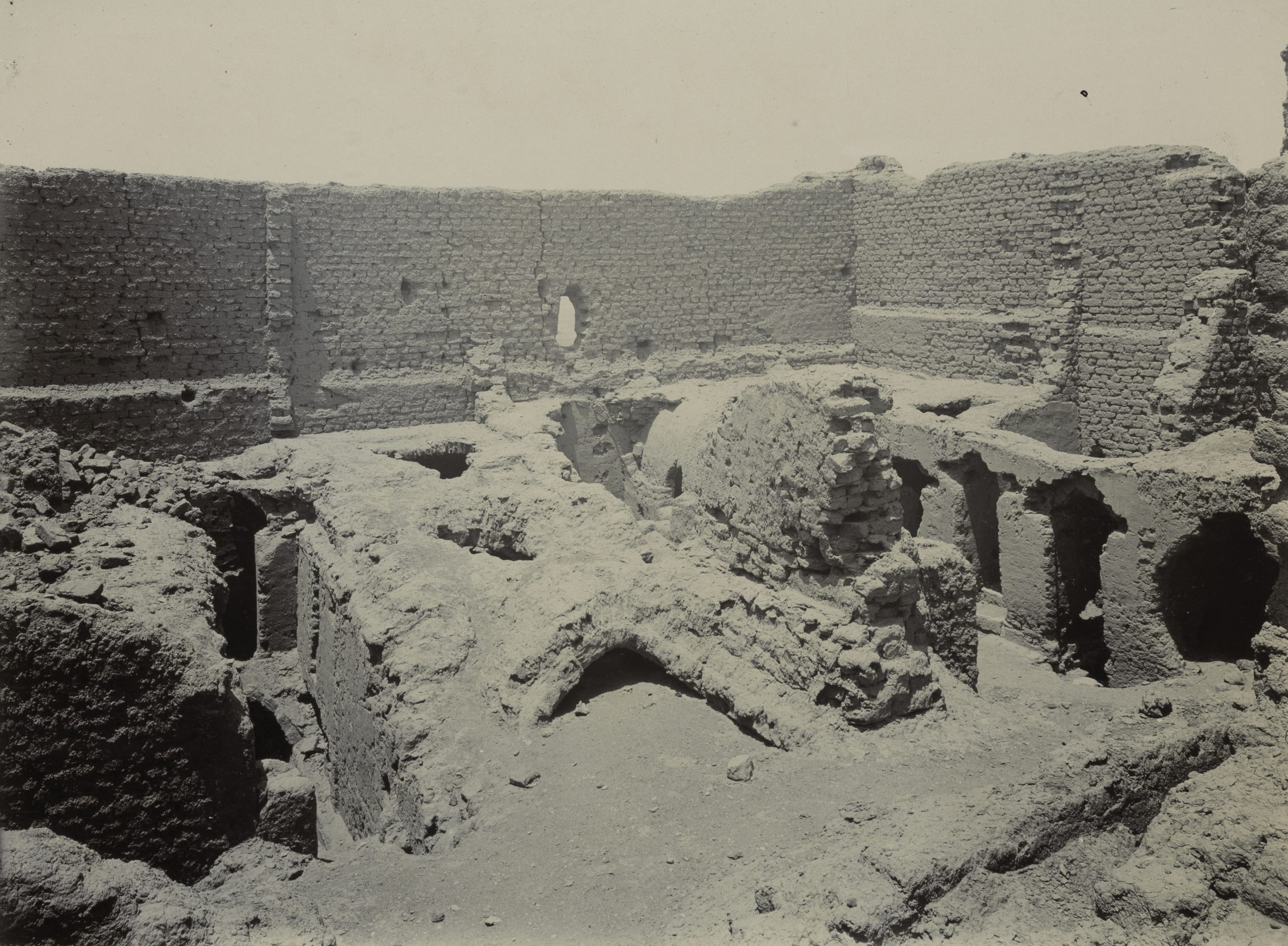
| Archaeological research | The earliest archaeological intervention at Dayr Muṣṭafā Kāšif is attributable to the Metropolitan Museum of Art (MMA) expedition in Kharga, but recent archival work has substantially clarified what can and cannot be claimed about this activity. In February 2024, the Kharga archives of the MMA were examined specifically to resolve earlier ambiguities. The archives contain no trace of excavation activity at the site in 1907–1908; the photographs from that period appear to be views of the monument rather than documentation of excavations. By contrast, the archival guide includes references indicating that excavation took place in 1931, notably including a group described as “five inscribed potsherds” (in fact: three Coptic ostraca, one Greek ostracon, and one painted fragment with a bird). These records also help explain the probable findspot of four fragmentary Coptic biblical parchment leaves held by the MMA, whose physical condition (heat-shrink deformation) is consistent with the fire event attested archaeologically at the site, making it likely they were recovered by the MMA team from Dayr Muṣṭafā Kāšif rather than generically from “Kharga/Baǧawāt” (Ghica et al. 2024b, 155–160). In 1963, W. Müller-Wiener published the first detailed architectural study of the complex, proposing that the monument developed out of a rock-cut structure; this remains a foundational contribution for the architectural interpretation of the site. Later activity by the local inspectorate is reported but partly contradictory. According to Manṣūr ʿUṯmān (former director of the Copto-Islamic Inspectorate in Kharga), local inspectors cleared/excavated parts of the complex in the late 1980s/early 1990s (with inconsistencies in the reported dates), focusing especially on the south-west cells (ground and upper level), the Ptolemaic temple/tomb structure, the tower/northern sector, the westernmost N–S corridor, and the so-called “Ottoman kitchen” to the north; the inspectorate also created the access “road” up the slope. ʿUṯmān suggested that “maybe some ostraca and pottery” were found and stored in the inspectorate facility at the Kharga Museum. However, ʿA.ʿA.Ḫ. ʿAbd al-ʿAzīz (a local inspector involved in the road work) denied that excavations took place, so the scale and exact nature of this intervention remain uncertain (Ghica et al. 2024b, 149–154). In the 2000s, the site was revisited by the Institut français d’archéologie orientale (IFAO) under V. Ghica for architectural and epigraphic documentation, with field seasons in February, March, and September 2007. The site was then integrated into the South Kharga Oasis Survey (SKOS) framework in December 2008, when brick-straw was sampled from multiple standing walls for radiocarbon dating and surface ceramics were screened; an additional targeted ceramic check was conducted in January 2012. Renewed systematic work began with the Norwegian-Egyptian mission / DEChriM in October–November 2021, combining cleaning and targeted excavation with full-site documentation (photography for a photogrammetric model, AutoCAD mapping, and material study). Work concentrated in the south-west ground-floor zone (including the ‘temple’/Ptolemaic structure and adjacent spaces, the lower cells, and connecting corridors). It became clear that several of these areas had already been disturbed by earlier interventions (notably the MMA 1931 work and likely the inspectorate’s clearing), yet significant archaeological material remained in situ (Ghica et al. 2024b). A major stratigraphic excavation season followed in December 2022 (with continued field operations in 2023), focused on the second-storey church in the south-east corner and the underlying rooms and collapses. The work documented complex construction and destruction sequences, including evidence for a major fire event and subsequent rebuilding phases, supported by stratigraphy and radiocarbon modelling. The 2022 season produced a large body of material, especially written evidence: ceramic ostraca, wooden tablets, numerous papyrus fragments, and parchment (including Lycopolitan Coptic with Galatians 1:8–2:2), as well as codicological material such as a papyrus fragment from codex cartonnage (Acts 3:1–2) and other remarkable objects (e.g., seal impressions, codex-cover leather) (Ghica et al. 2024a). These discoveries substantially strengthen the case for a 4th-century monastic occupation, continuing into later periods. In November 2023, the mission also undertook restoration/conservation operations requested by the local inspectorate, overseen by Basem Gehad, including stabilisation and protective measures for vulnerable areas. The most recent intervention is the 2025 field season (23–27 February 2025), which reopened and deepened work in R21 (previously only partly investigated) and initiated excavation/cleaning in R25, one of the largest internal halls. Clearing in the R21 sector led to identifying additional adjacent spaces (R26 and R27) beneath the church’s liturgical areas; the lowest stratigraphy suggested a later reuse of an oratory space as a stable. In R25, architectural features (notably benches) suggest an assembly (synaxis) hall rather than a refectory, while the collapse-derived ceramic clusters point to food preparation/dining and storage activities in upper rooms. The 2025 season also included renewed protective works over key rooms and other site-support conservation tasks. Publication of the excavation results is ongoing; in particular, the Greek and Coptic ostraca from the 2022 season are being edited and published as among the earliest documentary sources for monasticism from the site. |
Bibliography
• Bagnall, R. S. 2001a. “The Camp of Hibis.” In Essays and Texts in Honour of J. David Thomas, edited by T. Gagos and R. Bagnall, 3-9. Oakville: American Society of Papyrologists.
• Bagnall R. S. 2001b. “A Coptic Graffito from the Valley Building at Deir Mustafa Kashef.” In Essays and Texts in Honour of J. David Thomas, edited by T. Gagos and R. Bagnall, 263. Oakville: American Society of Papyrologists.
• de Bock, W. 1901. Matériaux pour servir à lʼarchéologie de lʼÉgypte chrétienne. 34-37. Saint Petersburg: Eugéne Thiele.
• Ghica, V. 2012. “Pour une histoire du christianisme dans le désert Occidental d’Égypte.” Journal des savants 2: 189-280.
• Ghica, V. 2016. “Vecteurs de la christianisation de l’Égypte au IVe siècle à la lumière des sources archéologiques.” In Acta XVI Congressus Internationalis Archaeologiae Christianae, Rome 22-28.9.2013, edited by Olof Brandt and Gabriele Castiglia, 242. Città del Vaticano: Pontificio Istituto di Archeologia Cristiana.
• Ghica, V. 2019. “L’archéologie du monachisme égyptien au IVe siècle: État de la question.” In Nag Hammadi à 70 ans, qu’avons-nous appris? Nag Hammadi at 70: What Have We Learned? Colloque international, Québec, Université Laval, 29-31 mai 2015, edited by Eric Crégheur, Louis Painchaud and Tuomas Rasimus, 131-132. Leuven, Paris, Bristol: Peeters.
• Ghica V. 2025. “Christian Archaeology in Kharga Oasis: Recent Fieldwork”, in C.A. Hope, P.L. Polkowski, J.R. Anderson, L. Kilroe (eds), The Oasis Papers 10: The Land Where the Sun Goes Down - the Archaeology of Egypt's Western Desert. Proceedings of the Tenth International Conference of the Dakhleh Oasis Project, Dakhleh Oasis Project Monograph 26, Bicester: Archaeopress, pp. 65-87.
• Ghica, V., M. Abdelaziz 2026. “3D visualisation of fourth-century Christian monuments and archaeological sites of Egypt,” in S. Mainieri, R. Pirelli (eds.), Ancient Egypt, New Technologies. Proceedings of the International Conference, 2nd edition, 5–7 July 2023, University of Naples ‘L’Orientale’, Serie Egittologica 6, Naples: Unior Press, pp. 89-97.
• Ghica, V., M. Elefante, R. Williams, B. Gehad 2024. “The 2022 and 2023 Field Seasons at Dayr Muṣṭafā Kāšif (Kharga Oasis).” Analecta Papyrologica 38/2, 189-248.
• Ghica V., F. Lemaire, M. Müller 2025. “Some Pieces of a Fourth-Century Monastic Archive of Coptic and Greek Ostraca and Wooden Tablets from Dayr Muṣṭafā Kāšif.” Analecta Papyrologica 39/1 (2025), 91-121.
• Ghica, V., R. Williams, B. Gehad, M. Elefante 2024. “The 2021 excavation season at Dayr Muṣṭafā Kāšif (Kharga Oasis).” Analecta Papyrologica 37/1, 149-182.
• Grossmann, P. 2002. Christliche Architektur in Ägypten. Leiden, Boston, Cologne: Brill.
• Lythgoe, A. M. 1908. “The Egyptian Expedition.” The Metropolitan Museum of Art Bulletin, vol. 3, 5 (May): 83-86.
• Müller-Wiener, W. 1963. “Christliche Monumente im Gebiet von Hibis (el-Kharga).” Mitteilungen des Deutschen Archäologischen Instituts Kairo 19: 121-140.
• Reddé, M. 1991. “l’ouest du Nil: une frontière sans soldats, des soldats sans frontière.” In Roman Frontier Studies 1989. Proceedings of the XVth International Congress of Roman Frontier Studies, edited by V.A. Maxfield and M.J. Dobson, 485-493. Exeter: University of Exeter Press.
• Reddé, M. 1999. “Sites militaires romains de l’oasis de Kharga.” Bulletin de l’Institut français d’archéologie orientale 99: 377-396.
• Wagner, G. 1987. Les Oasis d’Égypte à l’époque grecque, romaine et byzantine d’après les documents grecs: Recherches de papyrologie et d’épigraphie grecques. Cairo: Institut français d’archéologie orientale.
Authors
Suggested citation
 Json data