DAYR AL-BALĀYZA (ABBA APOLLŌ MONASTĒRION)
Place names
| Greek | Ἀββᾶ Ἀπολλῶ μοναστήριον | Ἀββᾶ Πουλει Πἐτρα |
| Coptic | pmonasth(rion) napa apollw | pxagios apa apollw | tpetra apa apollw | apa pole | apa apoulw | tpetra |
| Arabic | دير البلايزة |
| English | Deir el-Bala’izah |
| French | Dair al-Balaiza | Dayr al-Balayza | Deir Balaiza |
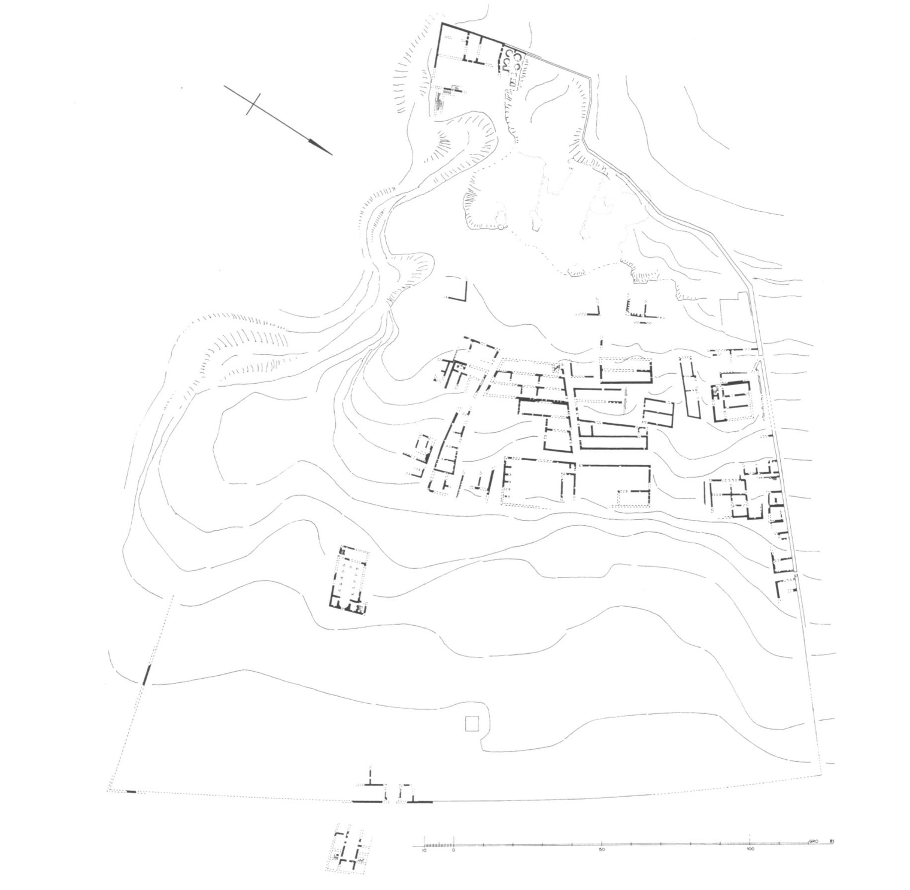
Site map
Site information
| DEChriM ID | 31 |
| Trismegistos GeoID | 3025 |
| Pleiades ID | 756520 | PAThs ID | 92 |
| Ancient name | Abba Apollō monastērion |
| Modern name | Dayr al-Balāyza |
| Latitude | 27.032623439070143 |
| Longitude | 31.233417391777042 |
| Date from | 650 |
| Date to | 750 |
| Typology | Monastic settlement |
| Dating criteria | Documentary texts |
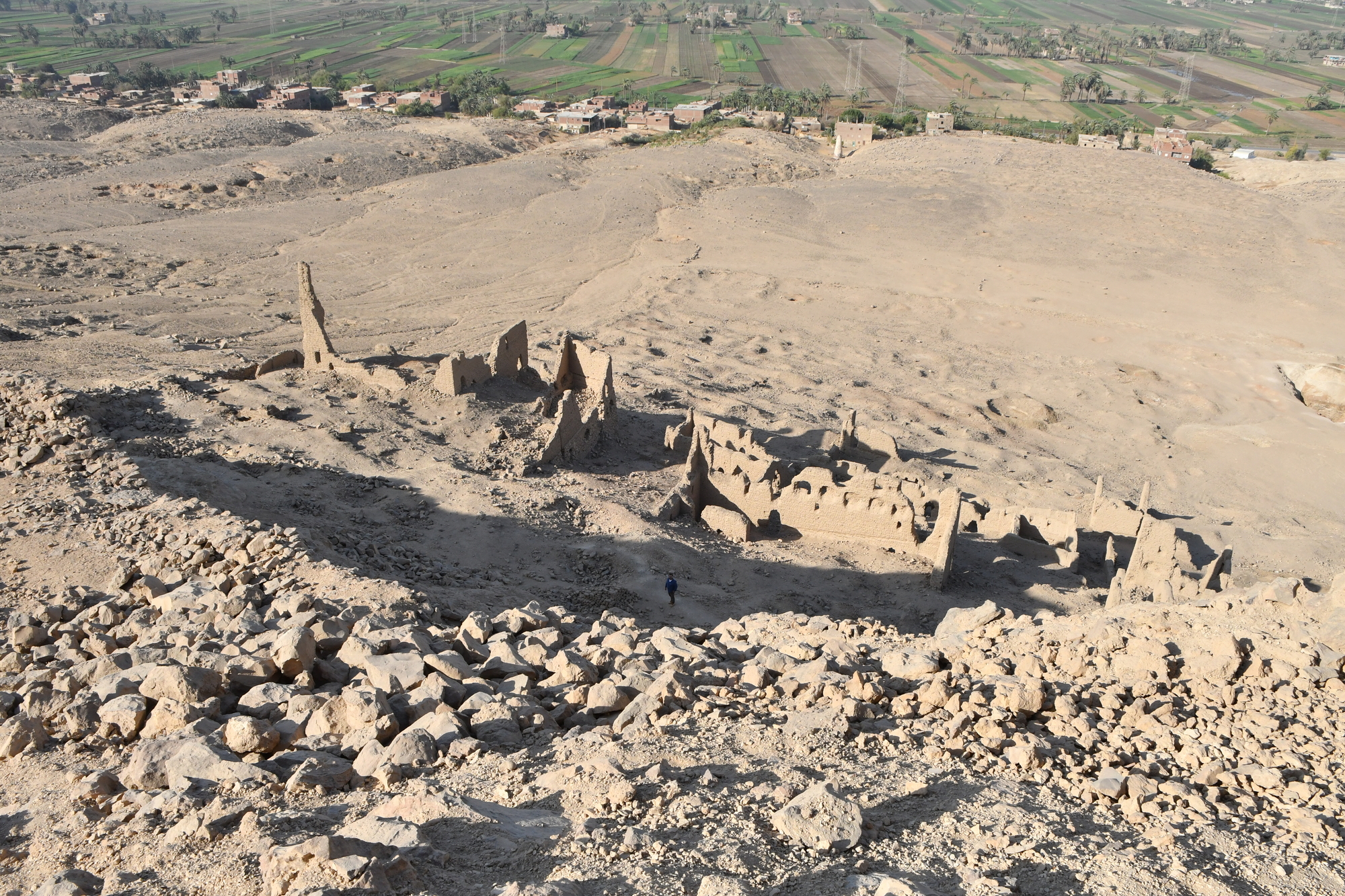
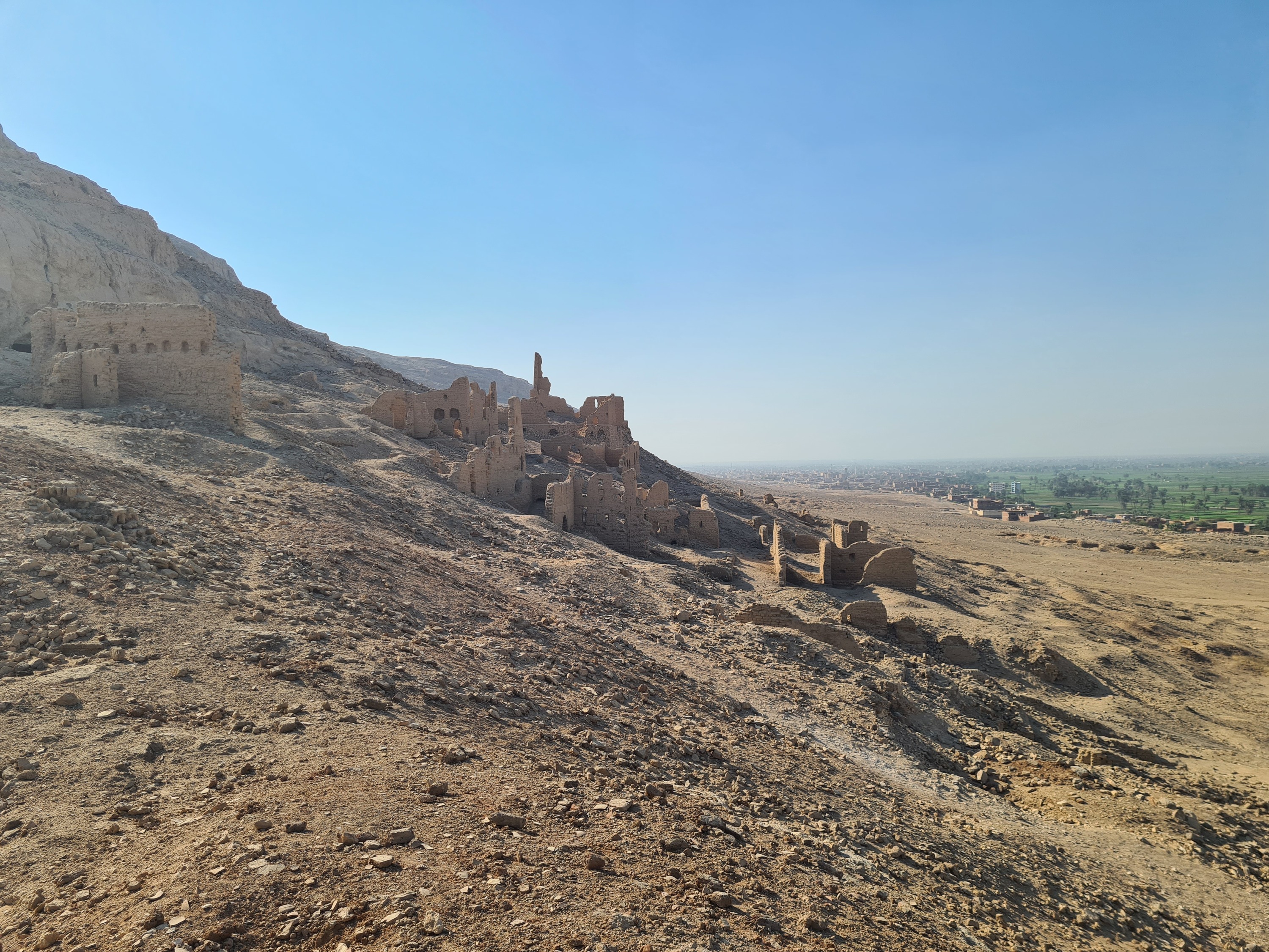
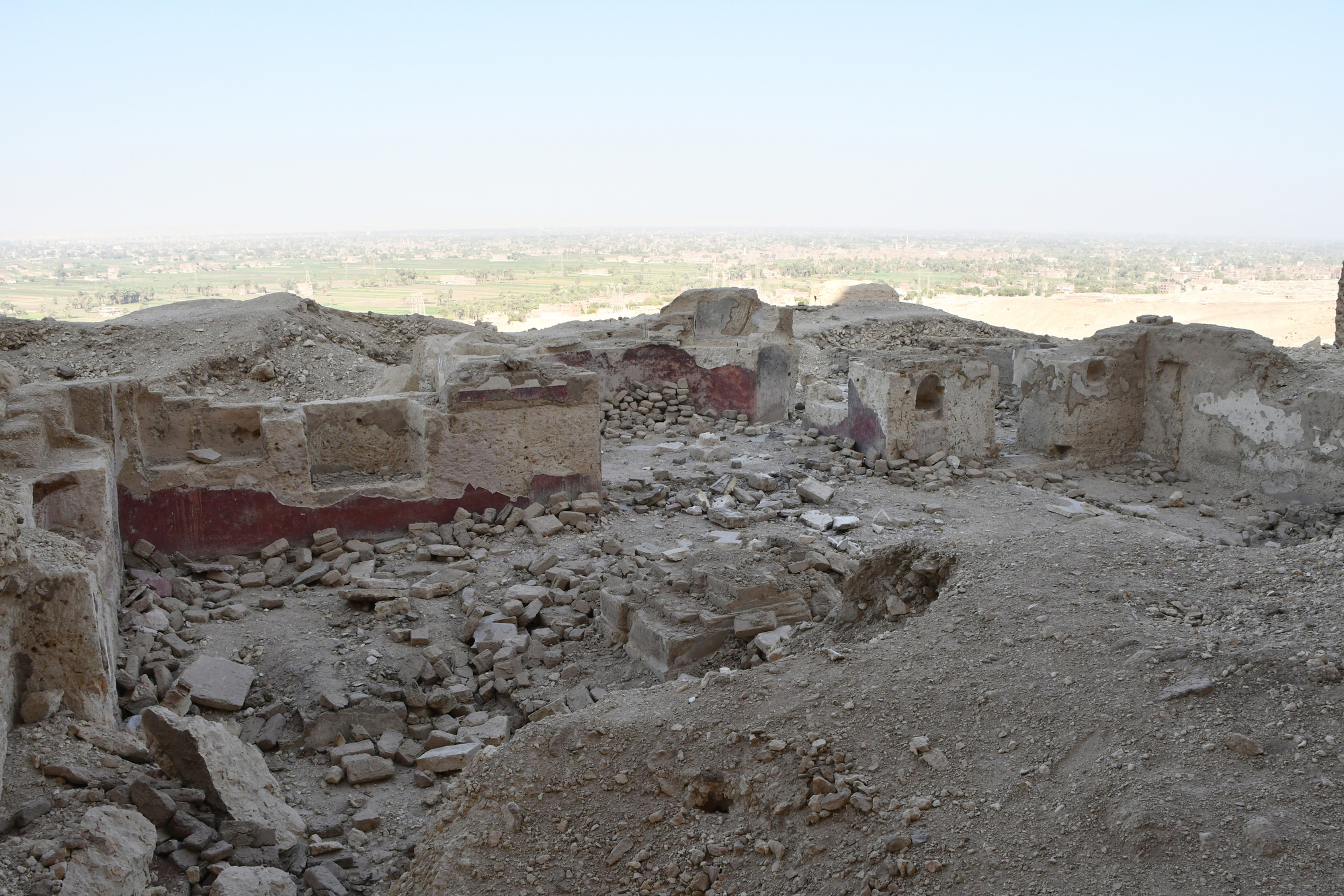
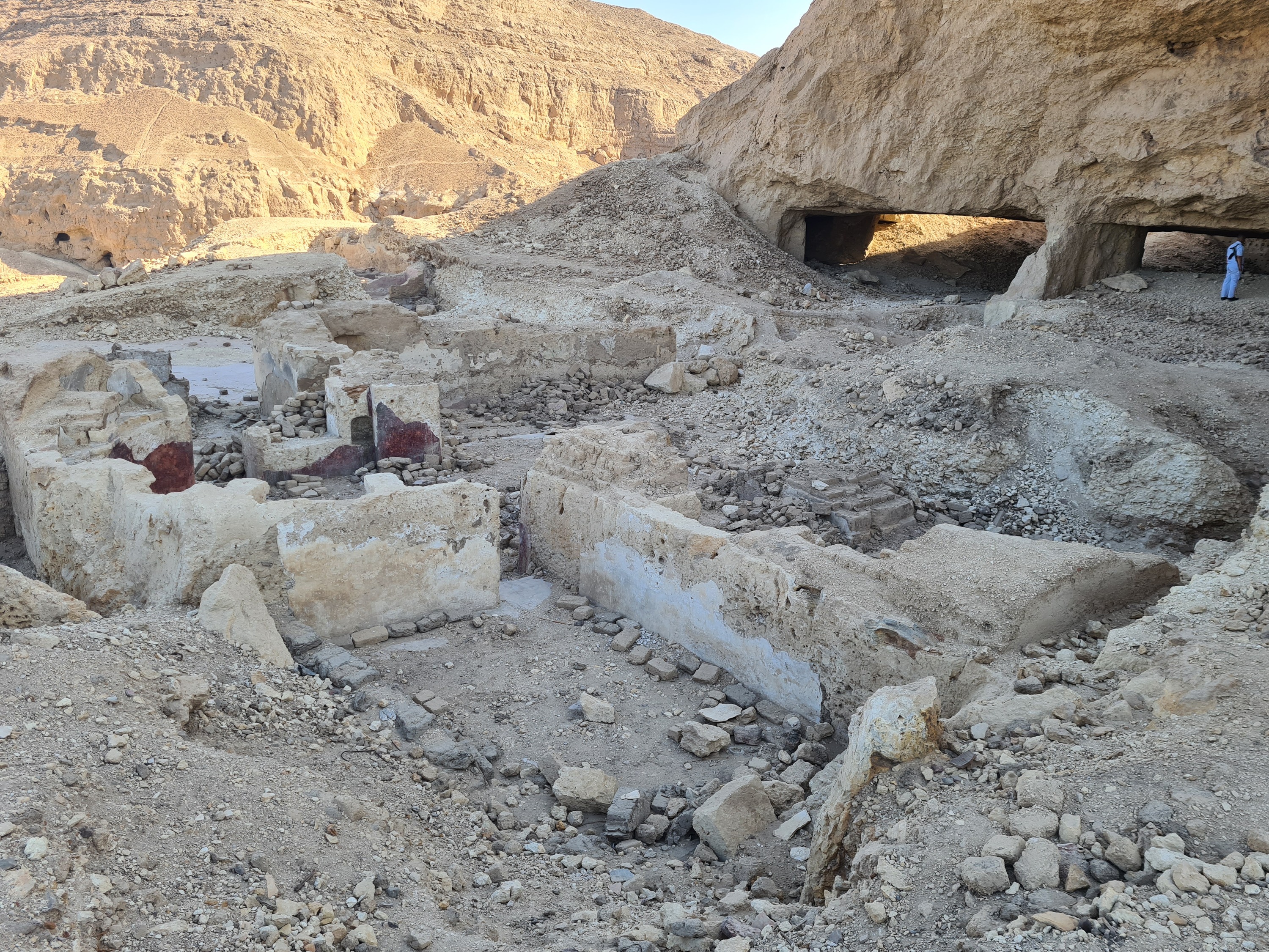
| Description | Dayr al-Balāyza is a walled monastic complex situated c. 15km south of Asyūt on the left bank of the Nile. The site is best known for the plethora of papyrological documents which were recovered during the course of excavations in the beginning of the 20th century (Flinders Petrie 1907: 1-2; Kahle 1954). It is thanks to these texts that the ancient name of the site is known. Majority of these belong to the 7th-8th century, and it is to this period that the occupation of the site appears to predominantly belong, though there are several documents which are attributable to the 4th-5th century (objects). It is possible that these were simply brought to the site at a later time, however, in which case they are not definitive attestation of 4th century monastic occupation of the site. The settlement appears to have developed out of re-occupied caves which had initially been created through quarrying activities, attributable to either Ptolemaic or Roman times (Grossmann 1989: 1879; Coquin et al. 1991: 787). The settlement gradually expanded eastwards, down the slope of the gebel. Two churches have been identified at the site, one situated partially within a cave and another in the south-eastern area of the site. The eastern area of the larger ‘cave church’ was completely covered by rubble when Peter Grossmann visited the site in the 1980s (Grossmann 1993: 181-185). He drew a plan nonetheless, but the structure is arguably unrecognisable as a church (Grossmann 1993: fig. 2. A drawing can also be found in al-Syriany and Habib 1990: 89). It is likely due to this that the same plan was not included in Grossmann’s monograph from 2002. This area of the structure has since been revealed, either through illicit excavations or official excavations of the local inspectorate, revealing a nave some 13m in width, with a raised apse accompanied by pastophoria to the north and south. The pastophorion to the north was accessible only from within the apse while that to the south was accessible from within the apse as well as the eastern end of the southern aisle. The walls of the sanctuary retain traces of white, red, and green painted plaster. |
| Archaeological research | The site was excavated by the British School of Archaeology in Egypt in the beginning of 1907 (Jan/Feb), with work directed by a Mr. Rhoades, Mr. Mackay, and Mr. Gregg. Despite the fact that majority of the season was dedicated to the site, with “a large part of the ruins (sic.) completely turned over…”, few details of this work were ever published (Flinders Petrie 1907: 1-2, 30). Images of a handful of objects were included in the school’s publication resulting from the season, but without archaeological context, the papyrological material being the priority(Flinders Petrie 1907: pl. 37b nos. 13-16 and pl. 38). Peter Grossmann visited the site in November 1982, conducting a survey over the course of six days, then visiting again in the summers of 1984 and 1985. This culminated in the first plan of the site as well as what is, to this day, the most thorough description of the site. Members of DEChriM visited the site in June 2022 in order to assess its condition as well as to obtain photographic documentation of the various features. While there, locals stated that excavations had been conducted by the local inspectorate, but where and when were not known. |
Bibliography
• Amélineau, E. 1893. La géographie de l’Égypte à l’époque copte, 463. Paris: Imprimerie Nationale
• Cappozzo, M. 2007. Il cristianesimo nel Medio Egitto, 133-139 & figs. 41-44. Todi: Tau.
• Coquin, R.-G., M. S. Martin and P. Grossmann. 1991. “Dayr al-Bala'yzah.” In The Coptic Encyclopedia, vol. 3, edited by A. S. Atiya, 786-787. New York: Macmillan.
• Flinders Petrie, W. M. 1907. Gizeh and Rifeh, 2 vols. London: Quaritch.
• Flinders Petrie, W. M. 1908. “Athribis.” British School of Archaeology in Egypt 14: 13 and plate 43.
• Goehring, J. E. 2015. “The Monastery of Apollo at Bala’iza and its Literary Texts.” In Christianity and Monasticism in Middle Egypt: Minya and Asyut, edited by G. Gabra and H. N. Takla, 41-56. Cairo: The American University in Cairo Press.
• Grossmann, P. 1986. “Die Unterkunftsbauten des Koinobitenklosters ‘Dair al-Bal?yza’ im Vergleich mit den Eremitagen der Mönche von Kellia.” In Le site monastique copte des Kellia: Sources historiques et explorations archéologiques, edited by P. Bridel, 33-39. Geneva: Mission suisse d’archéologie copte de l’Université de Genève.
• Grossmann, P. 1989. “Neue frühchristliche Funde aus Ägypten.” In Actes du XIe congrès international d’archéologie chrétienne. Lyon, Vienne, Grenoble, Genève, Aoste, 21-28 septembre 1986, edited by N. Duval, 1879-1882. Rome: École française de Rome.
• Grossmann, P. 1993. “Ruinen des Klosters Dair al-Balaiza in Oberägypten.” Jahrbuch für Antike und Christentum 36: 171-205.
• Grossmann, P. 2002. Christliche Architektur in Ägypten, 527-528 and figs 147-148. Leiden: Brill.
• Kahle, P. E. 1954. Bala’izah. Coptic Texts from Deir el-Bala’izah in Upper Egypt, 2 vols. Oxford: Oxford University Press.
• Leclant, J. 1984. “Fouilles et travaux en Égypte et au Soudan, 1982-1983.” Orientalia 53: 372.
• Leclant, J and G. Clerc. 1985. “Fouilles et travaux en Égypte et au Soudan, 1983-1984.” Orientalia 54: 367.
• al-Syriany, S. and B. Habib. 1990. Guide to Ancient Coptic Churches & Monasteries in Upper Egypt. Location: Institute of Coptic Studies, Department of Coptic Architecture.
• Timm, S. 1984-1992. Das christlich-koptische Ägypten in arabischer Zeit: Eine Sammlung christicher Stätten in Ägypten in arabischer Zeit, unter Ausschluß von Alexandria, Kairo, des Apa-Mena-Klosters (Dēr Abū Mina), der Skētis (Wādi n-Naṭrūn) und der Sinai-Region, vol. 2, 686-691. Wiesbaden: Dr Ludwig Reichert.
Authors
Suggested citation
 Json data