QAṢR AL-ĠAYṬ (AWITI)
Place names
| Arabic | قصر غيط |
| English | Qasr Ghet | Qasrawet |
| French | Qasr Ghêt | Qasr-Gheit | Qasr Wit |
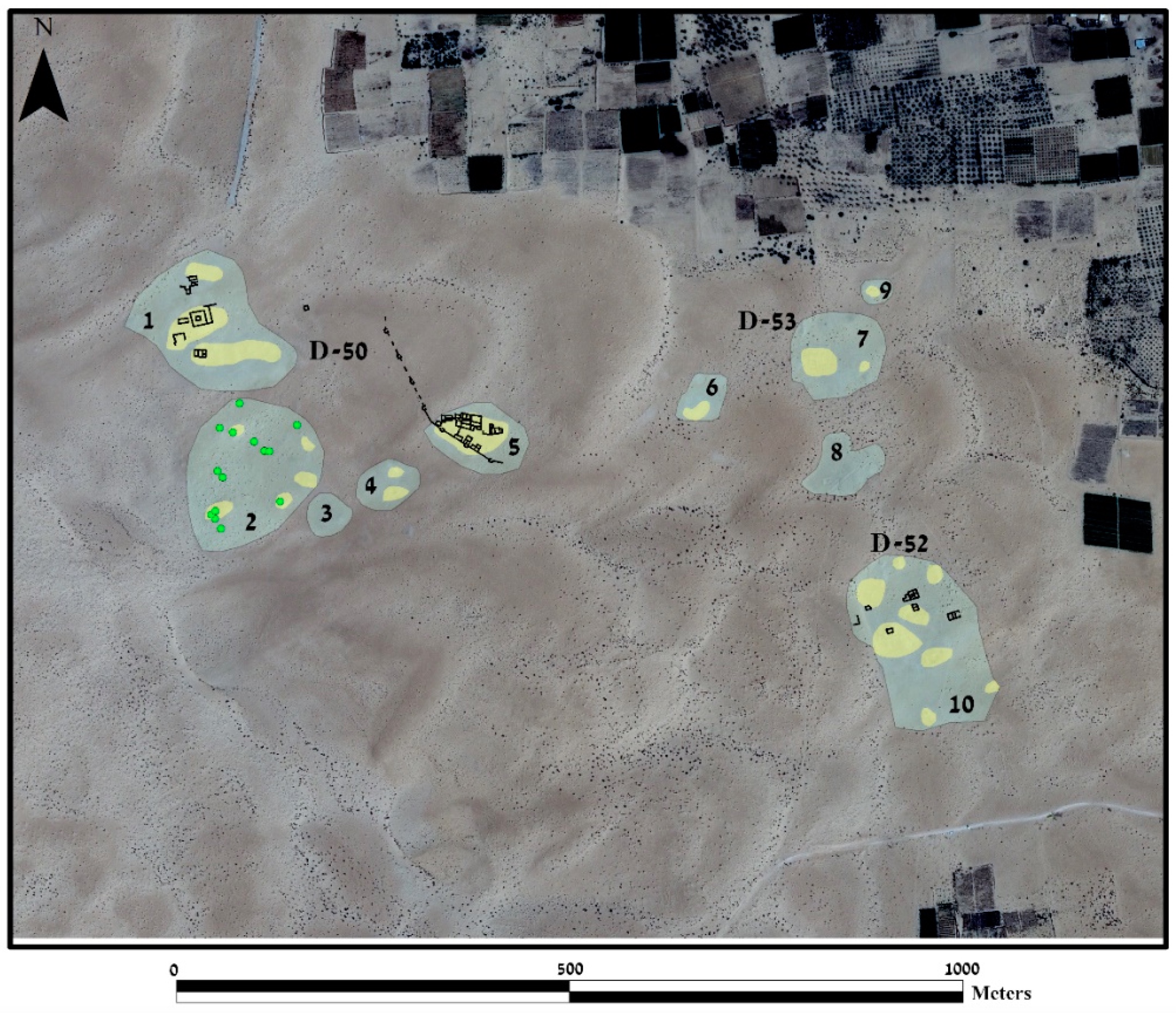
Site map
Site information
| DEChriM ID | 45 |
| Trismegistos GeoID | 2705 |
| Pleiades ID | 688010 | PAThs ID | - |
| Ancient name | Awiti |
| Modern name | Qaṣr al-Ġayṭ |
| Latitude | 30.916512 |
| Longitude | 32.810827 |
| Date from | -140 |
| Date to | 400 |
| Typology | Town |
| Dating criteria | Ceramic, coinage, written material. |
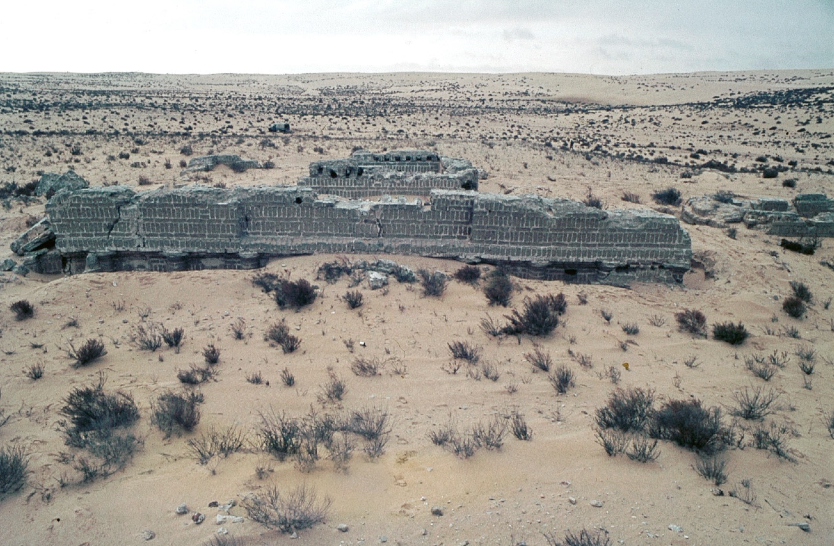
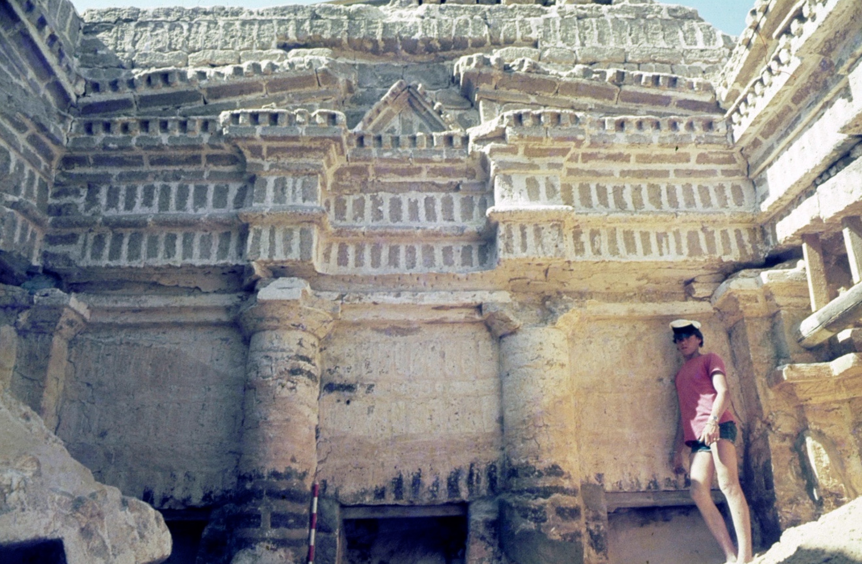
| Description | Qaṣr al-Ġayṭ, referred to by the excavators as ‘Qasrawet’, is situated in North Sinai, 18km south of the Mediterranean coast and 30km east of ancient Pelusium. Understood to have been initially occupied by the Nabateans from the second century BCE, it was abandoned around the third century CE, before being reoccupied and transformed into a Roman military camp in the fourth century (Oren 1982: 24, fig. 1; Tsafrir 1982: 214; Rokéah 1983: 95). The name of the Nabatean settlement and its precise function are unknown. Based on a dedicatory inscription found by Clédat (Starcky 1955: 153-156; Strugnell 1959: 33-35; Verreth 2006: 671-674; Paprocki 2019: 119), it has been hypothesised to have been Awiti, a Nabatean shrine of the goddess al-Kutba. Tsafrir identifies the site with the capital city of the Arab tribe of Autaei, mentioned by Pliny, and additionally associated the Roman camp with Castrum Autaei (Tsafrir 1982: 212-214). The ancient remains extend over an area of some 75 acres, situated in a shallow depression bound by shifting sand dunes (Oren 1982: 203). The earlier, Nabatean, settlement, which seems to date from the second century BCE, includes two monumental temples and an extensive necropolis (Oren 1982: 203, 208). It seems that, during this period, the settlement was not a city, but rather an administrative, commercial and religious center along a caravan route, described by Paprocki as a ‘caravanserai’ (Oren 1982: 206; Paprocki 2019: 119). The Roman period structures, located atop of the ‘domestic sector’ of the Nabatean settlement, were enclosed by a fortified wall and comprised predominantly of domestic structures clustered on narrow alleys, many of which, at the time of excavation, were preserved up to the roof level (Oren 1982: 209; Stewart et al. 2018: 3). The numerous artefacts procured from these houses, including hundreds of coins and an ostrakon, attest to a fourth century period of occupation, with the settlement hurriedly abandoned, though not destroyed, at the end of that century (Oren 1982: 209; Arthur and Oren 1998: 195; Rokéah 1983: 93-96; see Kool for the coins). Artefacts recovered from these houses also included clay oil lamps depicting Jewish (menorah and shofar) and Christian (staurograms) symbols, leading to the idea that the camp was manned by both Christian and Jewish soldiers (Oren 1982: 209-210, pl. 29c). |
| Archaeological research | Qaṣr al-Ġayṭ was discovered in 1909 by Jean Clédat, who conducted a brief excavation season in 1911, considering that it must have functioned as a Nabatean emporium, then a Roman garrison. Clédat’s work was brief, and was not accompanied by further exploration until 1975 and 1976, when the site was excavated as part of the North Sinai Survey (NSS) of Ben Gurion University of the Negev, directed by Eliezer D. Oren with the aid of the Israel Academy of Sciences and Humanities and the Southern Command of the IDF (Oren 1982: 203). The survey, conducted between 1972 and 1982, covered an area of approximately 2000 square kilometers, leading to the identification of 1300 sites ranging from the Middle Palaeolithic to Medieval times, of which c. 327 were represented by material from the Byzantine period. Qaṣr al-Ġayṭ was one of 28 sites chosen to be excavated (Arthur and Oren 1998: 193; Stewart et al. 2018: 2). Excavations were conducted on the central site (D50) and six satellite settlements on the east of the site (D51–56). Although there are a number of publications related to this excavation, the earliest of which are in Hebrew, no final report is available (Rosenthal-Heginbottom 2016: 184). Additionally, the study of the Nabatean temples was never completed due to the death of Ehud Nezer, who was tasked with their publication (Rosenthal-Heginbottom 2015: 154). Given current security threats in the Sinai, not to mention the strained relations between Israel and Egypt, fieldwork is currently impossible. In 2017, however, additional work was conducted by the Israeli team with the aid of Synthetic Aperture Radar (SAR) satellite imagery. The data obtained indicated the existence of numerous structures that had not been identified during fieldwork, likely attesting to either recent excavation or looting, rather than simple shifting of the sand dunes (Stewart et al. 2018: 7). |
Bibliography
• Arthur, P. and E. D. Oren. 1998. “The North Sinai Survey and the Evidence of Transport Amphorae for Roman and Byzantine Trading Patterns.” Journal of Roman Archaeology 11: 193-212.
• Kool, R. (a) Coin Finds of Qasrawet, draft available online: https://www.academia.edu/34545443/Coin_Finds_of_Qasrawet_DRAFT_VERSION
• Kool, R. (b) The Coins of North Sinai Survey (1972-1978), draft available online: https://www.academia.edu/34545390/The_Coins_of_the_North_Sinai_Survey_1972_1978_Text_DRAFT_VERSION
• Clédat, J. 1910. “Notes sur l’Isthme de Suez.” Annales du Service des antiquités de l’Égypte 10: 234-237.
• Clédat, J. 1912. “Fouilles à Qasr Gheit, mai 1911.” Annales du Service des antiquités de l’Égypte 12: 145-168, pls. I-III.
• Figueras, P. 2000. From Gaza to Pelusiam: Materials for the Historical Geography of North Sinai and Southwestern Palestine (332 BCE-640 CE). Beer-Sheva: Ben-Gurion University of the Negev Press.
• Gawlikowski, M. 2003. “The Nabatean Temple at Qasrawet.” In Egyptology at the Dawn of the Twenty-First Century: Proceedings of the Eighth International Congress of Egyptologists, Cairo, 2000, edited by Z. A. Hawass and L. P. Brock, 195-199. Cairo: American University in Cairo Press.
• Littmann, E. and D. Meredith. 1954. “Nabatean Inscriptions from Egypt-II.” Bulletin of the School of Oriental and African Studies, University of London 16, 2: 211-246, esp. 230-232.
• Margovsky, Y. 1971. “שלושה מקדשים בצפון סיני (Three Temples in Northern Sinai).” Qadmoniot 4: 18-21.
• Netzer, E. 2003. Nabatäische Architektur insbesondere Gräber und Tempel. Zabern: Mainz: Verlag.
• Oren, E. 1980. “Survey of Northern Sinai, 1972-78.” In קדמוניות סיני : מחקרים בתולדות חצי־האי (Sinai in Antiquity. Researches in the History and Archaeology of the Peninsula), edited by Z. Meshel and I. Finkelstein, 129-146. Tel Aviv: ha-Ḳibuts ha-meʾuḥad.
• Oren, E. 1982. “Excavations at Qaswaret in North-Western Sinai: Preliminary Report.” Israel Exploration Journal 32.4: 203-211.
• Oren, E. and E. Netzer. 1977. “יישובים מן התקופה הרומית בקאסארווית שבצפון-מערב סיני (Settlements of the Roman Period at Qasarweit in Northern Sinai).” Qadmoniot 10: 94-107.
• Paprocki, M. 2019. Roads in the Deserts of Roman Egypt. Analysis, Atlas, Commentary. Oxford, Philadelphia: Oxbow Books.
• Rokéaḥ, D. 1983. “Qasrawet: The Ostracon.” Israel Exploration Journal 33: 93-96.
• Rosenthal-Heginbottom, R. 2015. “Grave Goods and Nabatean Identity: Mampsis and Qasrawet.” Eretz-Israel 31: 154-165.
• Starcky, J. 1955. “Review: Nabatean Inscriptions from Egypt. Illustrated by Enno Littmann.” Syria 32, 1: 150-157.
• Stewart, C., E. D. Oren and E. Cohen-Sasson. 2018. “Satellite Remote Sensing Analysis of the Qasrawet Archaeological Site in North Sinai.” Remote Sens 10: 1-17.
• Strugnell, J. 1959. “The Nabatean Goddess Al-Kutba’ and Her Sanctuaries.” Bulletin of the American Schools of Oriental Research 156: 29-36.
• Tsafrir, Y. 1982. “Qaswaret: Its Ancient Names and Inhabitants.” Israel Exploration Journal 32: 212-214.
• Verreth, H. 2006. The Northern Sinai from the 7th Century BC till the 7th Century AD. A Guide to the Sources, 662-674. Leuven: Peeters.
Authors
Suggested citation
 Json data