AL-FILUSIYYA (OSTRAKINĒ)
Place names
| Greek | Ὀστρακίνη |
| Latin | Ostracine | Ostracina | Ostracena |
| Coptic | ostrakinh | trakinh |
| Hebrew | סרקאני | אסתרוקנית | אסתרוקנית | אסתרוקנית |
| Arabic | الفلسية |
| English | Ostrakine | Assdrakina | Ostranike | El-Felusiyat |
Site map
Site information
| DEChriM ID | 68 |
| Trismegistos GeoID | 1518 |
| Pleiades ID | 687993 | PAThs ID | 89 |
| Ancient name | Ostrakinē |
| Modern name | al-Filusiyya |
| Latitude | 31.11593 |
| Longitude | 33.430636 |
| Date from | -100 |
| Date to | 650 |
| Typology | City |
| Dating criteria | - |
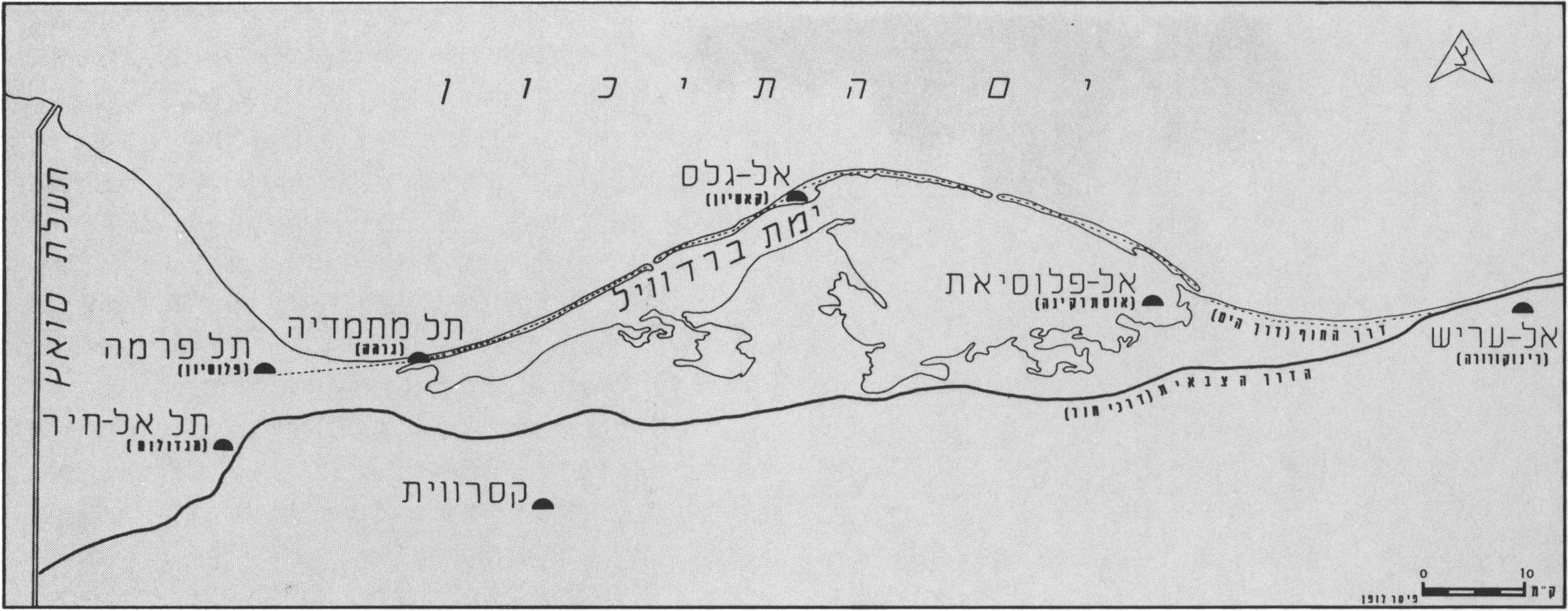
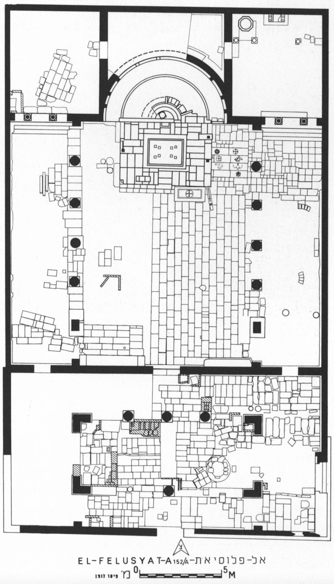
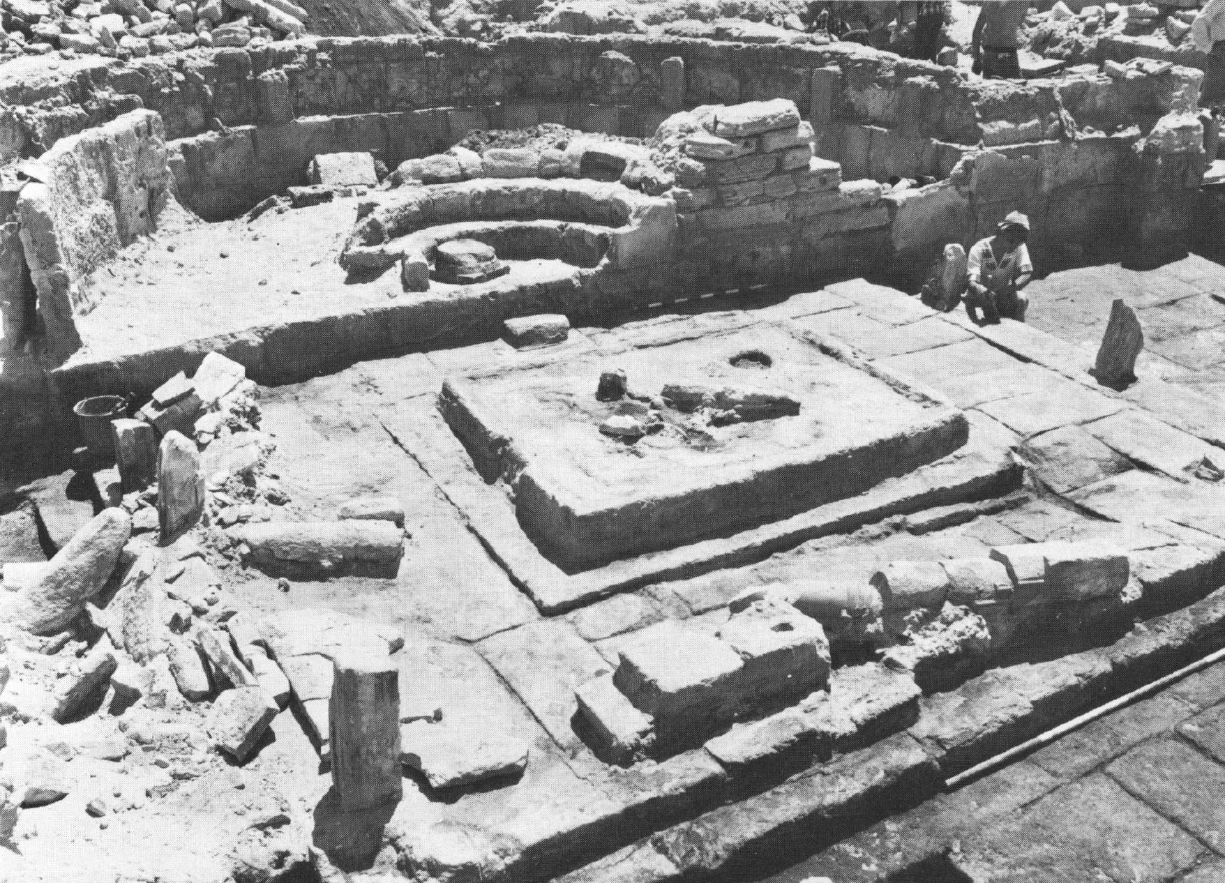
| Description | The ancient city of Ostrakinē, situated c. 98km east of Pelusium, is associated with the modern-day town of al-Filusiyya. Much of the ancient ruins are today submerged in the salt marshes of the Bardawīl Reef, with the remaining features located on four ‘islands’ – a large ‘main’ island, with three smaller islands situated to the north-east (Clédat 1910: 220, 222). The earliest attestation of the site is from the 1st century BCE, with the latest in the 7th century CE (Verreth 2006: 351, 353). Clédat considered that the city fell under the Arabs, while Grossmann supposed that it was destroyed by the Persians, but neither hypothesis can be confirmed based on the available sources (Grossmann 1991: 1414; Clédat 1916: 7, 10, 13). There were some figures who contested the correlation between ancient Ostrakinē and modern al-Filusiyya in the early 20th century, such as J. Maspero, but the relationship is today considered definite (Verreth 2006: 354, 395). A key portion of confirming evidence, which remains unexamined, are some 50 Greek ostraca found in a collapsed wall immediately south-west of the south basilica (A-151), all written by the same person, often mentioning the place name Ostrakinē. Taken to Cairo, these ostraca remain unedited (Clédat 1916: 27; Verreth 2006: 391). The textual sources make no mention of Christian monuments in the city, but there was undoubtedly a Christian community present in the fourth century given that the Arian bishop of Ostrakinē Theoktistos is mentioned having attended the synod of Seleukeia in 359 (Verreth 2006: 372). A total of three bishops are known from the mid-fourth to the mid-fifth century (Verreth 2006: 352). Despite their exclusion from known literary works, there are four Christian structures documented at the site: the north (A-?) and south basilicas (A-151, also known as the ‘large south church’), and a ‘fortified monastery’ (A-150/A), all excavated by Clédat, as well as an additional church found in the 70s, c. 70m north of the south basilica (A-152/A), described by Grossmann as being situated on an island… (Verreth 2006: 392; Grossmann 2002: 480). The fort structure, which was only partially excavated (Clédat 1916: figs. 2 and 3) was considered by Clédat to have been one of the joint monastery-fort buildings constructed in the Sinai by Justinian, and, while the presence of Christian occupants is unquestionable (Clédat 1916: 15-20 and figs. 5, 7, 9, 11), the idea that it was inhabited exclusively by monks has been rejected (Clédat 1916: 11, 15; Verreth 2006: 391 n. 1594). It is known that, in the second century, and likely also in the third, Roman soldiers were stationed at Ostrakinē, but additional information is wanting (Verreth 2006: 352). The large south church and the nearby church (A-151 and A-152/A respectively) were to the immediate north of the monastery (A-150/A), while further north was situated an industrial quarter (A-150/B) and the agora (A-153 = Taba Felusiyat) (Verreth 2006: 393). Some 2km north of the monastery was an area Clédat considered the harbour, though there is no definitive evidence supporting the notion that Ostrakinē was a harbour town (Verreth 2006: 352). This area is where the north basilica (A-?) is located (Clédat 1916a, p. 8; Verreth 2006: 390). Both the south basilica and the church identified by the Israelis were said to contain numerous burials, while the latter additionally included a reliquary (Grossmann 2002: 481; Verreth 2006: 391). Securely placing any of the occupation phases of these structures in the fourth century is difficult. The first of the two identified phases of the ‘fortified monastery’ is the 4th-5th century (Clédat 1916: 13-20; Kool, p. 3), while the three churches are all understood to date from the 5th century onwards, with the northern basilica presumed by Clédat to be the oldest (Kool, p. 2, 6-7; Clédat 1916: 27; Grossmann 2002: 477). Numismatic evidence potentially supports an earlier fourth century phase for the church found by the Israeli mission (A-152/A), but this hypothesis is somewhat unsubstantiated given the reality that the 4th century nummi are known to have remained in circulation well into the fifth century and even later (Kool, p. 6-7; Verreth 2006: 392). An additional monastery is mentioned by Oren, not far from the ‘small’ (i.e. northern?) basilica, but it was never excavated (Oren and Figueras 1982: 38; Verreth 2006: 391). The Christian occupation of the site is further supported by numerous explicitly Christian stelae existent in various museum collections, all of which are understood to come from the nearby cemetery of ‘el-Khuinat’ (2km), considered by Oren to have been one of the burial grounds of ancient Ostrakinē (Oren and Figueras 1982: 45; Oren 1993a: 1173; Dahari and Di Segni 2013). This presumed provenance is based on specific characteristics shared with stelae definitively originating from that cemetery – formulaic features of the text, decorative elements (the upper part being roughly in the shape of a human head with engraved facial features), and type of stone from which they are carved (kurkar) (Verret 2006: 399). These are roughly dated to the late fourth-fifth century (Dahari and Di Segni 2013, p. 127 and 136). See artefacts. |
| Archaeological research | Modern-day al-Filusiyya has only ever seen sparse interest, with fieldwork restricted to two brief excavation seasons. The first of these was conducted in 1914 by Jean Clédat, after first visiting, and ‘discovering’, the site in 1910. Clédat’s work comprised the excavation of the ‘fortified monastery’ and the north and south basilicas (Verreth 2006: 389). The next, and final, fieldwork to have been conducted was as part of the North Sinai Survey, directed by Eliezer D. Oren. The work at Ostrakinē comprised only a single excavation season in the winter of 1976-1977, resulted in the discovery of a third church. Unfortunately, only limited information was ever published about the fieldwork. The church found during the Israeli mission was re-examined in 1992 by Jean-Pierre Sodini and Mohamed Abd el-Samie, but no further information is available (Verreth 2006: 392). In addition to the flooding of the site, which has obscured many features, no detailed map of the archaeological area has ever been produced, meaning there is no general overview of the ancient city, including the extent of the inhabitation area (Verreth 2006: 389). |
Bibliography
Bibliography Referenced –
• Clédat, J. 1910. “Notes sur lʼIsthme de Suez. Autour du Lac de Baudouin.” Annales du Service des antiquités de lʼÉgypte 10: 220-224 and fig. 5.
• Cledat, J. 1916. “Fouilles à Khirbet el-Flousiyat (janvier-mars 1914).” Annales du Service des antiquités de lʼÉgypte 16: 6-32.
• Grossmann, P. 1991. “Khirbat al-Filūsiyyah.” In The Coptic Encyclopedia vol. 5, edited by A. S. Atiya, 1414-1415. New York: Macmillan Publishing Company.
• Grossmann, P. 2002. Christliche Architektur in Ägypten, 475-481. Brill: Leiden.
• Kool, R. Coin Finds of Ostrakine, draft available online: https://www.academia.edu/34545467/Coin_Finds_of_Ostrakine_DRAFT_VERSION
• Oren, E. 1977. “Ostrakine (el-Felusiat).” Hadashot arkheologiyot (Archaeological newsletter) 63-64: 72-75 (Hebrew).
• Oren, E. 1978. “יישוב נוצרי באוסטראקינה שבצפון סיני (A Christian Settlement at Ostracina in Northern Sinai)” Qadmoniot: A Journal for the Antiquities of Eretz-Israel and Bible Lands 11: 81-87 (Hebrew).
• Oren, E. 1980. “Survey of Northern Sinai, 1972-78.” In קדמוניות סיני : מחקרים בתולדות חצי־האי (Sinai in Antiquity. Researches in the History and Archaeology of the Peninsula), edited by Z. Meshel and I. Finkelstein, 129-146. Tel Aviv: ha-Qibuts ha-me'uḥad.
• Oren, E. 1993a. “Ostrakine.” In The New Encyclopedia of Archaeological Excavations in the Holy Land, vol. IV, edited by E. Stern, 1171-1173 and 1394-1396. New York: Simon and Schuster.
• Oren, E. 1993b. “A Christian Settlement at Ostrakine in North Sinai.” In Ancient Churches Revealed, edited by Y. Tasfarir, 305-314. Jerusalem.
• Verreth, H. 2006. The Northern Sinai from the 7th Century BC till the 7th Century AD. A Guide to the Sources, 351-412. Leuven: Peeters.
For a complete bibliography, see: Verreth 2006, p. 961-980 (esp. 961-962).
Authors
Suggested citation
 Json data