UMM AL-DABĀDĪB
Place names
| Arabic | أم الدباديب |
| English | Umm Dabadib | Umm el-Dabadib |
| French | Omm Dabadib | Oum el-Dabadib |
Site map
Site information
| DEChriM ID | 8 |
| Trismegistos GeoID | 61709 |
| Pleiades ID | 776237 | PAThs ID | - |
| Ancient name | - |
| Modern name | Umm al-Dabādīb |
| Latitude | 25.729920 |
| Longitude | 30.421458 |
| Date from | -100 |
| Date to | 499 |
| Typology | Village |
| Dating criteria | - |
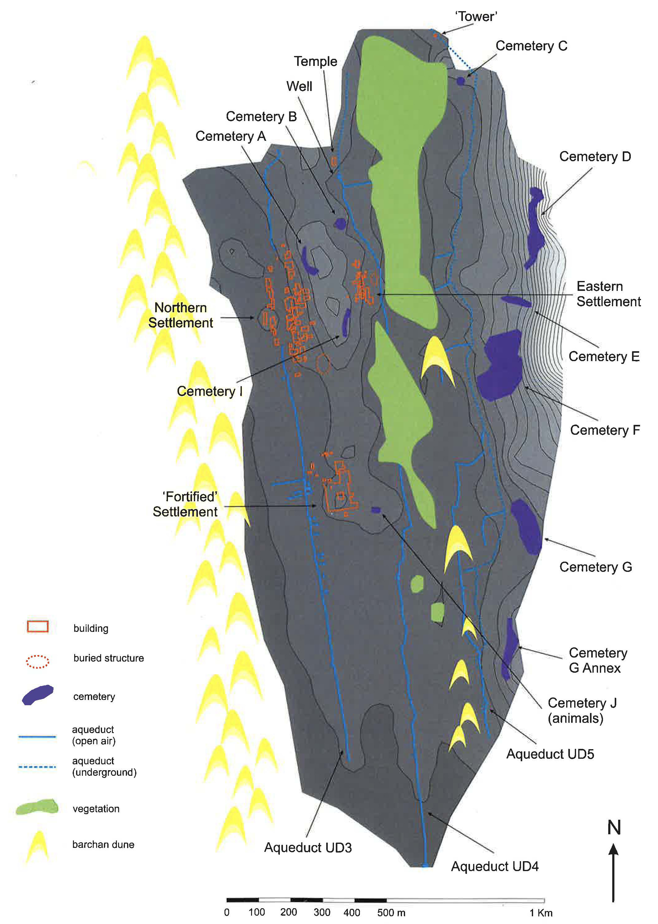
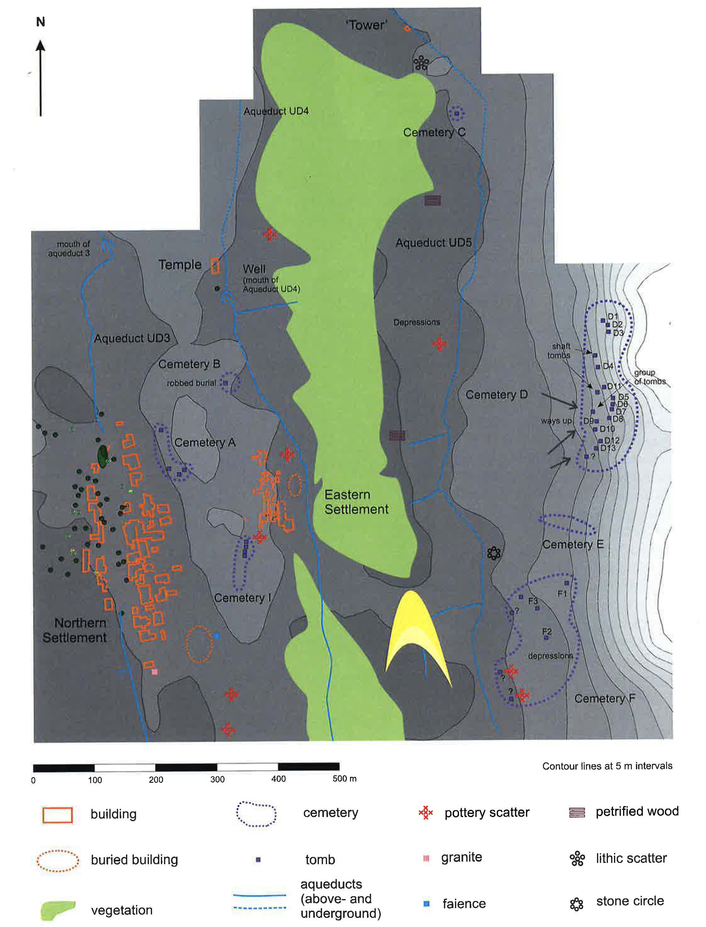
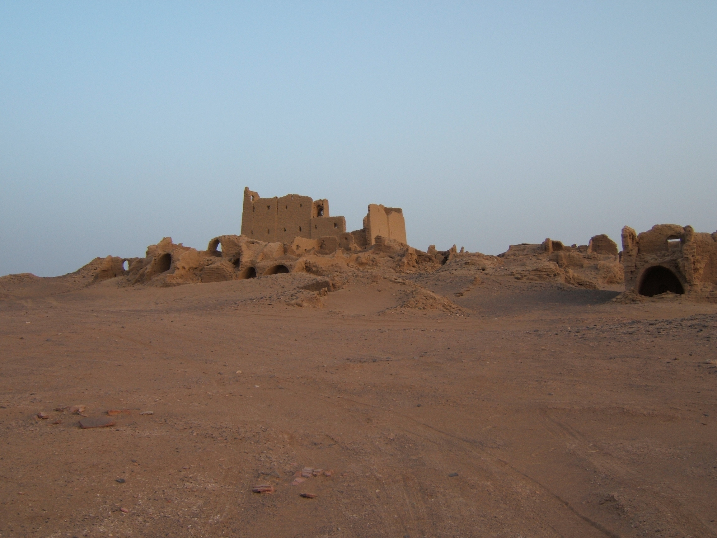
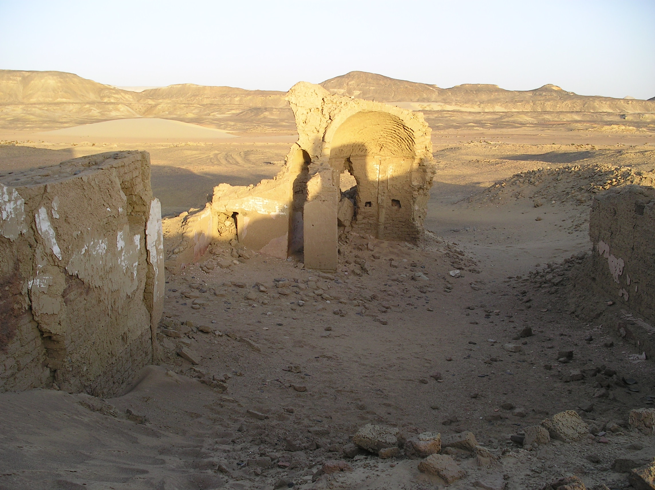
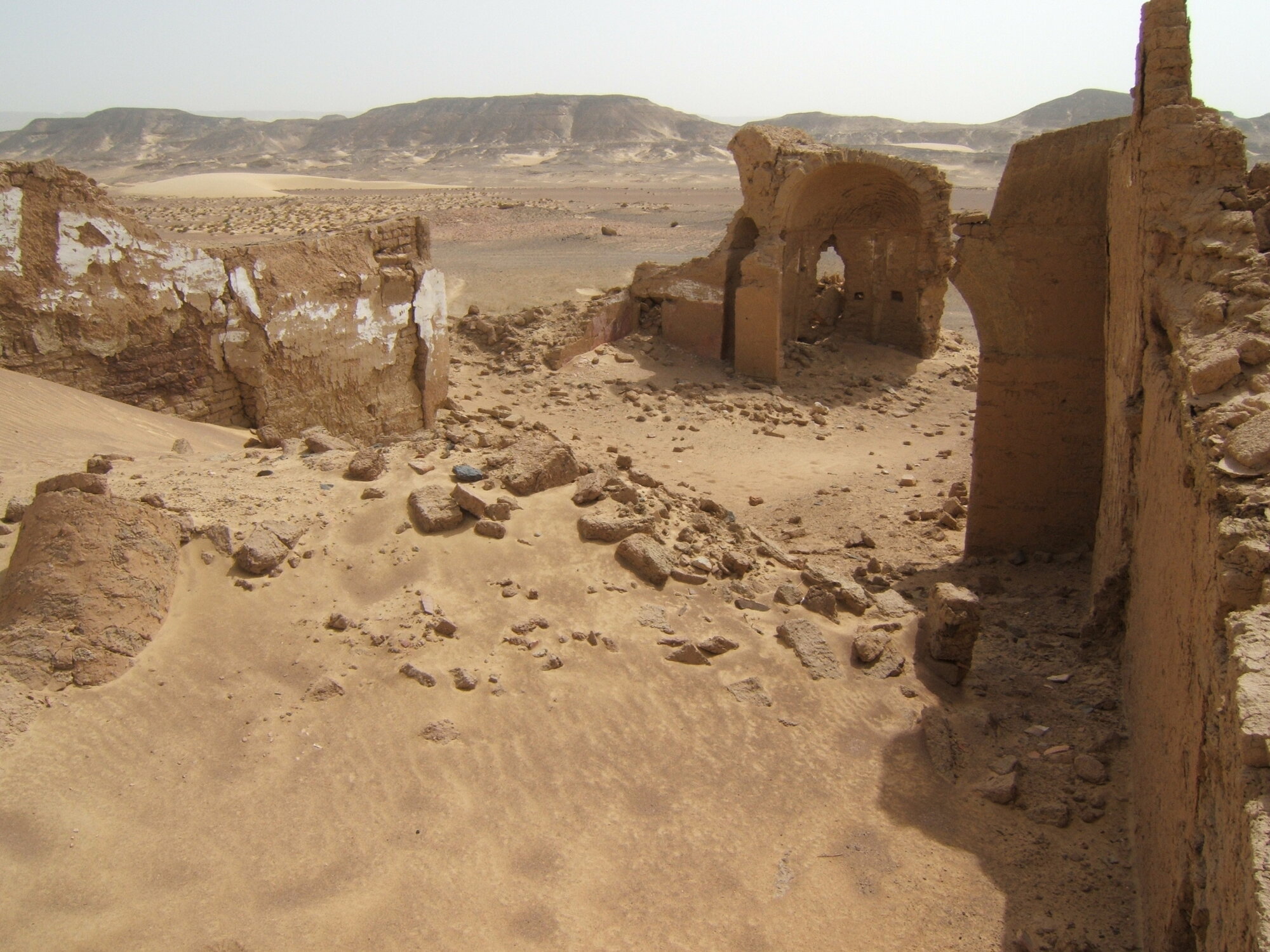
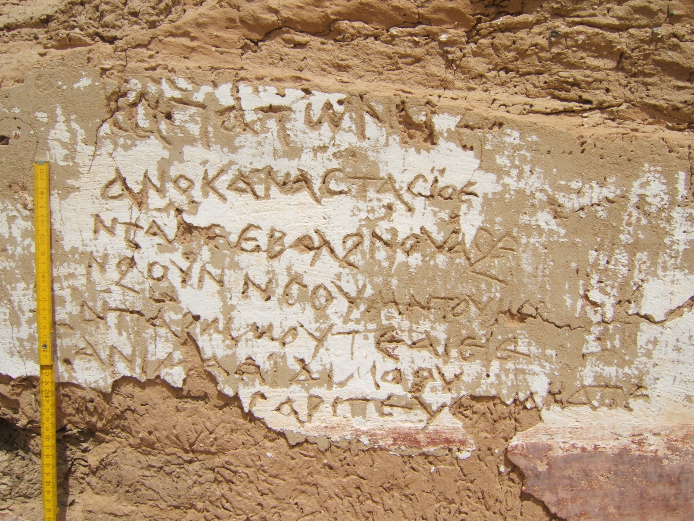
| Description | Umm al-Dabādīb is a remote site, located to the north of the Darb ʿAin Amūr and 45km N-W of the ancient city of Hibis (Rossi 2017: 20). It is also known as the ‘Oasis of Abbas’ and ‘Ain Elwan’ (Ball 1900: 53; Rossi & Ikram 2018: 205). It was probably inhabited since Ptolemaic times, with settlement intensification in the second/third century CE, with uncertain periods of occupation, and eventually being re-used and abandoned in the early twentieth century (Ghica 2012: 210; Rossi & Ikram 2018: 206). The site comprises a number of archaeological sectors divided into the Northern Settlement, the Eastern Settlement, and the ‘Fortified’ Settlement, with a number of cultivation areas in the west a number of aqueducts, some ten cemeteries and at least one hermitage (Rossi & Ikram 2006: 296). Northern Settlement The Temple ‘Fortified’ Settlement The ‘Fort’ The Church Eastern Settlement Hermitage |
| Archaeological research | The site has been visited and surveyed countless times. Initially visited and briefly described by Cailliaud in 1821, it was then visited by John Ball in 1898, and again by H. J. Beadnell in 1909 whose focus was the subterranean aqueducts (Beadnell 1909: 57). H. E. Winlock visited the site but did not publish anything, instead simply mentioning the presence of a well in a personal communication (unpublished notes in the Metropolitan Museum of Art). Elinor Wight Gardner and Gertrude Caton Thompson then visited the site in 1932-22, conducting a number of geological surveys (Gardner & Caton Thompson 1933). Ahmed Fakhry also wrote about the site focusing on the aqueducts, similarly to Beadnell (Fakhry 1974: 34). Systematic and extensive investigations did not begin until 1998, when Corinna Rossi visited the area, which led to the creation of the North Kharga Oasis Survey (NKOS), co-founded with Salima Ikram. The first fieldwork conducted occurred in 2002, which was the third season of NKOS, and consisted of GPS and theodolite surveys. A number of additional theodolite surveys were carried out between 2001 and 2007. Rossi then founded the Old Agricultural Sites and Irrigation Systems (OASIS) project in 2012, in collaboration with the MUSA Centre of the University of Napoli Frederico II. A number of 3D surveys of the Fortified Settlement and the entire agricultural system were carried out as part of OASIS between 2013 and 2015. In 2014 and 2015, Francesco Fassi and Alessandro Mandelli performed a 3D survey of the entire Fortified Settlement. The work conducted, and the information collected eventually enabled the creation of the LIFE project (“Living in a Fringe Environment”) for which Rossi partnered with the Politecnico di Milano and the MUSA Centre (Musei delle Scienze Agrarie) of the University of Napoli Frederico II. Rossi received an ERC Consolidator Grant for the project in 2015, and activities commenced in 2016. |
Bibliography
• Ball, J. 1900. Kharga Oasis: Its Topography and Geology. Cairo: National Printing Department.
• Beadnell H. LI. 1909. An Egyptian Oasis: An Account of the Oasis of Kharga in the Libyan Desert, with Special Reference to its History, Physical Geography, and Water-Supply. London: J. Murray.
• Blundell, H. W. 1894. “Notes sur une excursion à Khargueh, Dakhel, Farafrah et Behariyeh.” Bulletin de la Société khédiviale de géographie 4: 237.
• Caton Thompson, G. 1952. Kharga Oasis in Prehistory. London: Athlone Press.
• Cailliaud, F. 1821. Voyage à l’oasis de Thèbes et dans les déserts situés à l’Orient et à l’Occident de la Thébaïde fait pendant les années 1815, 1816 et 1817. Paris: Monsieur Jomard.
• Fassi, F., C. Rossi and A. Manelli. 2015. “Emergency Survery of Endangered or Logistically Complex Archaeological Sites.” International Archives of the Photogrammetry, Remote Sensing and Spatial Information Sciences XL-5/W4: 85-91.
• Fiorillo, F. and C. Rossi 2017. “Metric Analysis and Interpretation of the Unit of Measurement in the Late Roman fort of Umm al-Dabadib (Egypt).” In Proceedings of the 3rd IMEKO International Conference on Metrology for Archaeology and Cultural Heritage, Lecce, Italy, 23-25 October 2017. Budapest: Curran Associates, 139-44.
• Fiorillo, F. and C. Rossi. 2018. “3D Survey and Metric Analysis of the Late Roman Site of Umm al-Dabadib, Kharga Oasis (Egypt).” The International Measurement Confederation 7/3: 57-63.
• Gascou, J. and G. Wagner. 1979. “Deux voyages archéologiques dans l’Oasis de Khargeh.” Bulletin de l’Institut français d'archéologie orientale 79: 15.
• Gardner, E. W & G. Caton Thompson. 1933. “Summary Report on the Kharga Expedition.” Man (Journal of the Royal Anthropological Institute) 33: 178-180.
• Ghica, V. 2012. “Pour une Histoire du Christianisme dans le Désert Occidental d’Égypte.” Journal des savants 2: 189-280.
• Ghica, V. 2016. “Vecteurs de la christianisation de l’Égypte au IVe siècle à la lumière des sources archéologiques.” In Acta XVI Congressus Internationalis Archaeologiae Christianae, Rome 22-28.9.2013, edited by O. Brandt and G. Castiglia, 199 and fig. 9g. Città del Vaticano: Pontificio Istituto di Archeologia Cristiana.
• Grossmann, P. 1989. “Neue frühchristliche Funde aus Ägypten.” In Actes du XIe congrès international d’archéologie chrétienne. Lyon, Vienne, Grenoble, Genève, Aoste, 21-28 septembre 1986, edited by N. Duval, 1897-1898. Rome: École Française de Rome.
• Ikram, S. 2005. “Endangered Archaeology of the Kharga Oasis, Egypt.” Culture Without Context 5: 22-3.
• Ikram, S. and C. Rossi. 2002. “Surveying the North Kharga Oasis.” KMT: A Modern Journal of Ancient Egypt 13/4: 72-9.
• Jenkins G., D. McBride and C. Rossi. 1999. “Brief Report on the Umm el-Dabadib Project.” Annales du Service des antiquités de l’Égypte 74: 3-7.
• Rossi, C. 2000. “Umm el-Dabadib, Roman Settlement in the Kharga Oasis: Descriptions of the Visible Remains, with a Note on ‘Ain Amur.” Mitteilungen des Deutschen Archaologischen Instituts Abteilung Kairo 56: 235:52.
• Rossi, C. 2013. “Controlling the Borders of the Empire: The Distribution of Late-Roman ‘Forts’ in the Kharga Oasis.” In The Oasis Papers 6, Proceedings of the Sixth Conference of the Dakhla Oasis Project, edited by R. S. Bagnall, P. Davoli and C. Hope, 331–336. Oxford: Oxbow Books.
• Rossi C. 2016. “Italian Mission to Umm al-Dabadib, Season 2014 – Preliminary Report.” Mitteilungen des Deutschen Archaologischen Instituts Abteilung Kairo 72: 153-172.
• Rossi, C. 2017. “Survey, Conservation and Restoration in Egypt’s Western Desert: Combining Expectations and Context.” Restauro Archeologico 26/2: 20-35.
• Rossi C. 2018. “Italian Mission to Umm al-Dabadib, Season 2015 – Preliminary Report.” Mitteilungen des Deutschen Archaologischen Instituts Abteilung Kairo 74: 149-161.
• Rossi, C., G. B. Chirico, A. Migliozzi and S. Mazzoleni (forthcoming). “Greening the Desert at the southern edge of the Empire: the Irrigation System of the Late Roman Site of Umm al-Dabadib (Kharga Oasis, Egypt).” In Proceedings of the Mediterranean Forum of Water Sources, Matera, October 18-22, 2015.
• Rossi, C. and F. Fiorillo. 2018. “A Metrological Study of the Late Roman Fort of Umm al-Dabadib, Kharga Oasis (Egypt).” Nexus Network Journal 20: 373-391.
• Rossi, C. and S. Ikram. 2006. “North Kharga Oasis Survey 2003. Preliminary Report: Umm el-Dabadib.” Mitteilungen des Deutschen Archaologischen Instituts Abteilung Kairo 62: 279-306.
• Rossi, C. and S. Ikram. 2018. North Kharga Oasis Survey: Explorations in Egypt’s Western Desert. Leuven: Peeters.
• Rossi, C. and G. Magli. 2019. “Wind, Sand and Water: the Orientation of the Late Roman Forts in the Kharga Oasis (Egyptian Western Desert).” In Archaeoastronomy in the Roman World, edited by G. Magli, E. Antonello, J. A. Belmonte and A. César González-García, 153-166. Berlin: Springer.
• Rossi, C., A. Migliozzi, F. Fassi, A. Mandelli, G. B. Chirico, C. Achille and S. Mazzoleni. 2015. “Archeologia, Scienza e Tecnologia: lo Studio del Sito Tardo-Romano di Umm al-Dabadib (Oasi di Kharga, Egitto).” In Proceedings of the Seminar L.O.S.A.I. (Laboratori Open su Scienza, Arte e Innovazione) 2015. Napoli, Artstudiopaparo: 221-228.
• Wagner, G. 1987. Les oasis d’Égypte à l’époque grecque, romaine et byzantine d’après les documents grecs: Recherches de papyrologie et d’épigraphie grecques. Cairo: Institut français d’archéologie orientale.
Authors
Suggested citation
 Json data